HOME RANKINGS CHALLENGES ROUTES NEAR ME PLANNING SEARCH LOGIN
Switzerland
2022/08/22 19:12:02

Pischa Trail Davos

12 Downloads
0
 
Share

Key Takeaways / Scheda Tecnica

Disciplina:
Mountain Bike (MTB)
Percorso:
Pischa Trail Davos
Località:
Switzerland
Distanza:
20,79 km
Dislivello Positivo:
+1 031 mt (Quota Min: 1598m - Max: 2472m)
Difficoltà Tecnica:
3/5
Valutazione Panorami:
5/5
Formato Traccia:
GPX Download disponibile
Author
marco
(195)
Place
Switzerland
Km
20,79 km
Elapsed time
02:54:05
Vertical meters
+1 031 mt (1598 - 2472)
Route difficulty
Landscapes
Last update
2022/08/22 19:17:18
Comments
1
Description

Don't be fooled by the low mileage and elevation gain, because this is a tough ride due to the climb being completely on trail, some of it steep and technical. It's worth all the effort (you'll do less if you use the ebike) because the ridge trail is spectacular, as is the descent.

Start at Davos Adventure Park, where there is also a beautiful pumptrack and two dirt lines, with free admission. It climbs to the Flüela Pass and then takes a trail on the opposite side of the valley from the road.

Foto itinerario MTB Pischa Trail Davos - Switzerland

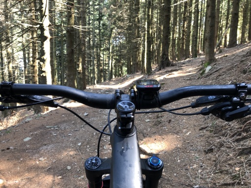
The gradient is never very steep, apart from a few short ramps, and it is completely rideable.

It becomes more difficult to stay in the saddle when crossing the road and climbing the opposite side, especially at the beginning because of some steep sections.

Foto itinerario MTB Pischa Trail Davos - Switzerland

Let's say that the 600 meters of elevation gain to the top station of the Pischa cable car (it was closed when I went, August 22, 2022) is 70% rideable, or even less if you are not in shape.

Foto itinerario MTB Pischa Trail Davos - SwitzerlandFoto itinerario MTB Pischa Trail Davos - Switzerland

The traverse from the cable car to the start of the actual descent is magnificent, with sweeping views everywhere.

Foto itinerario MTB Pischa Trail Davos - Switzerland

The descent is fairly smooth, except toward the end when there are a couple of bumpy switchbacks. The view of Lake Davos below is worth a photo stop.

Foto itinerario MTB Pischa Trail Davos - SwitzerlandFoto itinerario MTB Pischa Trail Davos - Switzerland

The path around the lake is off-limits to bikes, which is why we have to briefly follow a dirt road uphill that will take us back to the starting point.

Parking costs 5 chf per day.

The bike park bar/restaurant is worth a post-ride stop. In the evening hours it is sun-kissed and being outside sprawled out on the couches is a blast.

Download our free mobile app to send this route to your Garmin device or to navigate it on OSM maps. Android - iOS
Local weather
Tue 00:00
7 °C
Tue 12:00
13 °C
Wed 00:00
9 °C
Wed 12:00
8 °C
Thu 00:00
1 °C
Thu 12:00
2 °C
Fri 00:00
2 °C
Fri 12:00
7 °C
Sat 00:00
3 °C
Sat 12:00
3 °C

Graph

Nearest Routes

2022/08/09
- Switzerland
marco
(195)
45,62 km
Km
+1 575 mt
Vertical meters
Route difficulty
Landscapes
2022/08/08
- Switzerland
marco
(195)
23,54 km
Km
+213 mt
Vertical meters
Route difficulty
Landscapes
2023/08/28
- Switzerland
CrisB
(5)
38,27 km
Km
+695 mt
Vertical meters
Route difficulty
Landscapes
2025/08/24
- Switzerland
CrisB
(5)
89,17 km
Km
+2 300 mt
Vertical meters
Route difficulty
Landscapes
2023/08/20
- Switzerland
CrisB
(5)
34,63 km
Km
+1 038 mt
Vertical meters
Route difficulty
Landscapes
2022/08/03
- Switzerland
marco
(195)
6,24 km
Km
0 mt
Vertical meters
Route difficulty
Landscapes
2026/07/18
- Switzerland
avalonice
(8)
30,60 km
Km
+1 150 mt
Vertical meters
Route difficulty
Landscapes
2024/08/12
- Switzerland
Staff
(110)
26,02 km
Km
+1 005 mt
Vertical meters
Route difficulty
Landscapes
2026/08/05
- Switzerland
30,37 km
Km
+1 700 mt
Vertical meters
Route difficulty
Landscapes
77,62 km
Km
+2 267 mt
Vertical meters
Route difficulty
Landscapes

1 Comments