Italiano
 Deutsch
Sulle orme della ferrovia retica

The Albula valley is a paradise for anyone remotely interested in alpine railways, particularly Swiss railways. This route passes very close to the railroad route from Filisur to Davos, among gorges, ravines, and jaw-dropping trails.
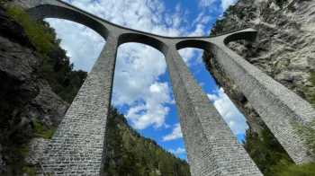
We start in Filisur by climbing up a lovely little road that will take us to higher elevations and onto a really combed path to the highest railway viaduct on the entire Rhaetian Railway, the Wiesen viaduct. One can transit it by bicycle, admiring the stream below from an impressive 88 meters in height.
At Wiesen, the station is very quaint, and equipped with a fresh water fountain that I recommend filling up as you now ascend to the village of the same name.
It too is very beautiful and still in time. We continue uphill and then enter the woods on a dirt road that seems gentle but then climbs inexorably steeply to the entrance of a fantastic path.
It is the one that takes us to the foot of Monstein. Never difficult, it is exposed in places but we are always in the woods, so the exposure is not the scary kind. It is practically all cyclable.
We go up to Monstein and from the little village we go up again to the start of the trail, also beautiful, which takes us first to Jenisberg, and then to the Bärentritt Gorge. The second part is a bit steeper with hairpin bends that are never too tight.
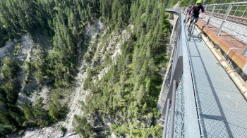
When we reach the Albula River we take a super spectacular dirt road that takes us back to the Wiesen station, from which we take another beautiful trail along the Albula back to Filisur, not before passing under the spectacular Landwasser viaduct.