HOME RANKINGS CHALLENGES ROUTES NEAR ME PLANNING SEARCH LOGIN
Italy - Trentino-Alto Adige/Südtirol, BZ
2025/11/19 10:51:48

Forcella del Diavolo-Teufelsjoch

2 Downloads
1
 
Share

Key Takeaways / Scheda Tecnica

Disciplina:
Mountain Bike (MTB)
Percorso:
Forcella del Diavolo-Teufelsjoch
Località:
Italy - Trentino-Alto Adige/Südtirol, BZ
Distanza:
92,23 km
Dislivello Positivo:
+2 900 mt (Quota Min: 305m - Max: 3160m)
Difficoltà Tecnica:
2/5
Valutazione Panorami:
5/5
Formato Traccia:
GPX Download disponibile
Author
nonnocarb
(324)
Place
Italy - Trentino-Alto Adige/Südtirol, BZ
Km
92,23 km
Elapsed time
09:15:45
Vertical meters
+2 900 mt (305 - 3160)
Route difficulty
Landscapes
Last update
2025/11/19 11:38:27
Comments
0
Description

Very challenging route, both for the total elevation gain and for the extreme slope of the road leading to the fork at 3170 m.
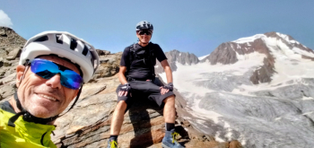
Foto itinerario MTB Forcella del Diavolo-Teufelsjoch - Italy - Trentino-Alto Adige/Südtirol, BZ

Almost entirely rideable by ebike, with regular bike on the other hand there will be pushing the bike for almost a thousand meters of elevation gain.
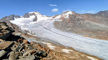
Foto itinerario MTB Forcella del Diavolo-Teufelsjoch - Italy - Trentino-Alto Adige/Südtirol, BZ

The views are nothing short of fabulous, with views of the Palla Bianca at 3738 m and all its glacier below.
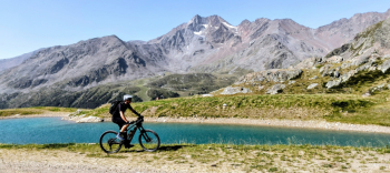
Foto itinerario MTB Forcella del Diavolo-Teufelsjoch - Italy - Trentino-Alto Adige/Südtirol, BZ

From Merano you ride to Naturno and then up along the Schnalstal valley to Maso Corto (if you want to do less elevation gain, you can start at Vernago Lake). From Maso Corto the very steep service road to the ski lifts begins, leading up to 3000 meters. The last stretch is to be done on foot.
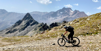
Foto itinerario MTB Forcella del Diavolo-Teufelsjoch - Italy - Trentino-Alto Adige/Südtirol, BZ

The return can be done on the same road or, for the more technical, on the beautiful trail to Maso Corto and then more side trails that reach below the village of Certosa.
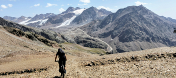
Foto itinerario MTB Forcella del Diavolo-Teufelsjoch - Italy - Trentino-Alto Adige/Südtirol, BZ

Download our free mobile app to send this route to your Garmin device or to navigate it on OSM maps. Android - iOS
Local weather
Tue 00:00
15 °C
Tue 12:00
17 °C
Wed 00:00
15 °C
Wed 12:00
14 °C
Thu 00:00
13 °C
Thu 12:00
15 °C
Fri 00:00
10 °C
Fri 12:00
12 °C
Sat 00:00
10 °C
Sat 12:00
13 °C

Graph

Nearest Routes

2023/02/26
- Italy - Trentino-Alto Adige/Südtirol, BZ
nonnocarb
(324)
36,78 km
Km
+1 610 mt
Vertical meters
Route difficulty
Landscapes
2024/07/20
- Italy - Trentino-Alto Adige/Südtirol, BZ
Staff
(110)
86,52 km
Km
+3 200 mt
Vertical meters
Route difficulty
Landscapes
2022/10/30
- Italy - Trentino-Alto Adige/Südtirol, BZ
nonnocarb
(324)
86,32 km
Km
+2 856 mt
Vertical meters
Route difficulty
Landscapes
2025/11/21
- Italy - Trentino-Alto Adige/Südtirol, BZ
nonnocarb
(324)
66,02 km
Km
+2 000 mt
Vertical meters
Route difficulty
Landscapes
2024/11/18
- Italy - Trentino-Alto Adige/Südtirol, BZ
nonnocarb
(324)
67,38 km
Km
+1 900 mt
Vertical meters
Route difficulty
Landscapes
2024/05/29
- Italy - Trentino-Alto Adige/Südtirol, BZ
nonnocarb
(324)
65,56 km
Km
+2 000 mt
Vertical meters
Route difficulty
Landscapes
2023/03/01
- Italy - Trentino-Alto Adige/Südtirol, BZ
nonnocarb
(324)
49,83 km
Km
+950 mt
Vertical meters
Route difficulty
Landscapes
2022/11/04
- Italy - Trentino-Alto Adige/Südtirol, BZ
nonnocarb
(324)
32,17 km
Km
+1 852 mt
Vertical meters
Route difficulty
Landscapes
2023/03/06
- Italy - Trentino-Alto Adige/Südtirol, BZ
nonnocarb
(324)
32,34 km
Km
+1 500 mt
Vertical meters
Route difficulty
Landscapes
2023/03/01
- Italy - Trentino-Alto Adige/Südtirol, BZ
nonnocarb
(324)
86,66 km
Km
0 mt
Vertical meters
Route difficulty
Landscapes

0 Comments