HOME RANKINGS CHALLENGES ROUTES NEAR ME PLANNING SEARCH LOGIN
Italy - Trentino-Alto Adige/Südtirol, TN
2025/10/23 16:22:19

Catinaccio d'Antermoia per Ebike

90 Downloads
2
 
Share
Author
Place
Italy - Trentino-Alto Adige/Südtirol, TN
Km
28,86 km
Elapsed time
07:28:34
Vertical meters
+1 700 mt (1364 - 2565)
Route difficulty
Landscapes
Last update
2025/10/23 16:48:31
Comments
0
Description

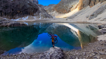
This ride is designed for Ebike given the gradients of the climbs that will be faced, impossible to do with classic MTB and will take us all the way to Lake Antermoia in the heart of the Dolomites. The bike ride can be found here. We climb up the val de Dona which, apart from the first 100 meters of warm-up, then immediately begins to climb with gradients bordering on tipping, fortunately the bottom is good and often cemented. As we reach the top, the valley opens up giving us an amazing view of the massif. At the bottom of the valley the forest road ends and the climb turns into a trail, and in addition to the slope there is rocky, loose terrain with tight turns; you need training and a lot of technique to get to the top.

I stronglydiscourage going up to the Lake and the refuge of the same name during tourist periods (July/August) as the trail is extremely busy with tourists, alternatively you can avoid this section and head straight to Val Duron. Or go there on foot.

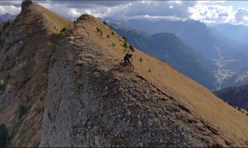
Compulsory lunch break at the lake and then start descending the same trail as you climbed until you get back to Val de Dona. From here continue to Forcella Ciampai and if you want you can reach the top of Mount Ponjin with one of the most beautiful ridges in all the Dolomites. Descent to Val Duron on a nice dirt trail, not extreme but with some technical passages to be careful (medium difficulty S3 with a couple of S4 points). From Val Duron back to Val de Dona on a nice traverse to reach the last part of the descent that presents a nice mix of situations, also not extreme but some nosepress requires it.

In conclusion a ride for those who, even using an e-bike, have a good physical shape and are familiar with technical climbs and descents of classic alpine style.

**I repeat I DO NOT recommend the most touristy times to do this ride if you do not want to be shot (as far as the Rifugio and Lake Antermoia section is concerned)**


Download our free mobile app to send this route to your Garmin device or to navigate it on OSM maps. Android - iOS
Local weather
Fri 00:00
10 °C
Fri 12:00
13 °C
Sat 00:00
10 °C
Sat 12:00
14 °C
Sun 00:00
9 °C
Sun 12:00
17 °C
Mon 00:00
9 °C
Mon 12:00
17 °C
Tue 00:00
12 °C
Tue 12:00
18 °C

Graph

Nearest Routes

2023/03/06
- Italy - Trentino-Alto Adige/Südtirol, TN
nonnocarb
(319)
20,80 km
Km
+1 120 mt
Vertical meters
Route difficulty
Landscapes
2022/08/19
- Italy - Trentino-Alto Adige/Südtirol, TN
pozzoligio
(93)
51,42 km
Km
+2 048 mt
Vertical meters
Route difficulty
Landscapes
2022/08/20
- Italy - Trentino-Alto Adige/Südtirol, TN
pozzoligio
(93)
28,10 km
Km
+791 mt
Vertical meters
Route difficulty
Landscapes
2022/10/22
- Italy - Trentino-Alto Adige/Südtirol, TN
nonnocarb
(319)
41,88 km
Km
+2 190 mt
Vertical meters
Route difficulty
Landscapes
2023/02/26
- Italy - Trentino-Alto Adige/Südtirol, TN
nonnocarb
(319)
24,50 km
Km
+1 500 mt
Vertical meters
Route difficulty
Landscapes
2023/07/28
- Italy - Trentino-Alto Adige/Südtirol, TN
pozzoligio
(93)
35,59 km
Km
+1 551 mt
Vertical meters
Route difficulty
Landscapes
2023/07/27
- Italy - Trentino-Alto Adige/Südtirol, TN
pozzoligio
(93)
47,84 km
Km
+2 292 mt
Vertical meters
Route difficulty
Landscapes
2023/07/25
- Italy - Trentino-Alto Adige/Südtirol, TN
pozzoligio
(93)
64,76 km
Km
+2 100 mt
Vertical meters
Route difficulty
Landscapes
2023/07/25
- Italy - Trentino-Alto Adige/Südtirol, TN
pozzoligio
(93)
55,87 km
Km
+1 637 mt
Vertical meters
Route difficulty
Landscapes
2024/07/30
- Italy - Trentino-Alto Adige/Südtirol, TN
Staff
(108)
32,71 km
Km
+1 088 mt
Vertical meters
Route difficulty
Landscapes

0 Comments