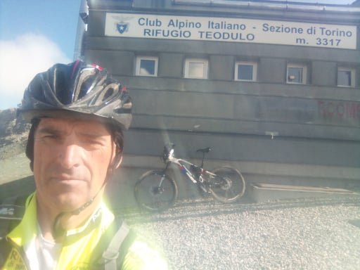
HOME RANKINGS CHALLENGES ROUTES POI PLANNING SEARCH LOGIN
Italy - Trentino-Alto Adige/Südtirol, TN
2023/07/28 13:19:08

Val Jumela, Sella Brunec, sentiero Pederiva, val Contrin

7 Downloads
1
 
Author
pozzoligio
(87)
Place
Italy - Trentino-Alto Adige/Südtirol, TN
Km
35,59 km
Elapsed time
04:38:47
Vertical meters
+1 551 mt (1299 - 2484)
Route difficulty
Landscapes
Last update
2023/07/29 09:13:26
Comments
0
Description

Fantastic tour with cycloalpine section, fantastic views. Departure from Pozza di Fassa on the very hard dirt road of Val Jumela to sella Brunech from slopes often over 20% .

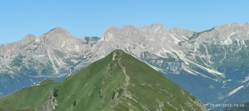
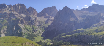
View towards the Catinaccio

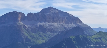
View toward Piz Boè.

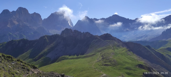
Now follow the Pederiva trail to the San Nicolò pass refuge. For those who, like me, have heavy ebikes, very hard uphill section to the first peak, it doesn't take long but it is a lot of effort on narrow and steep trail, then less for the second peak where you can see the refuge in the distance. From here on the sentieo improves and the pedalable sections begin, some safety iron ropes but you continue well and start to descend. At a vantage point you can see the Marmolada.

Now the path is all pedalable and you get to the refuge, from sella Brunch to the refuge I took 1h30 including stops to rest and take pictures, the view is always fantastic. Now long descent to the Contrin refuge, almost all in the saddle.

From the refuge follow the dirt road to Alba then Canazei and Pozza di Fassa. For those , like me, who have a heavy bike, it is tiring but very satisfying, I recommend the ride early in the morning, the Pederiva trail is quite busy and often narrow.

Download our free mobile app to send this route to your Garmin device or to navigate it on OSM maps. Android - iOS

Graph

Nearest Routes

2023/07/27
- Italy - Trentino-Alto Adige/Südtirol, TN
pozzoligio
(87)
47,84 km
Km
+2 292 mt
Vertical meters
Route difficulty
Landscapes
2023/07/25
- Italy - Trentino-Alto Adige/Südtirol, TN
pozzoligio
(87)
55,87 km
Km
+1 637 mt
Vertical meters
Route difficulty
Landscapes
2023/07/25
- Italy - Trentino-Alto Adige/Südtirol, TN
pozzoligio
(87)
64,76 km
Km
+2 100 mt
Vertical meters
Route difficulty
Landscapes
2023/02/26
- Italy - Trentino-Alto Adige/Südtirol, TN
nonnocarb
(266)
24,50 km
Km
+1 500 mt
Vertical meters
Route difficulty
Landscapes
2022/10/22
- Italy - Trentino-Alto Adige/Südtirol, TN
nonnocarb
(266)
41,88 km
Km
+2 190 mt
Vertical meters
Route difficulty
Landscapes
2022/08/20
- Italy - Trentino-Alto Adige/Südtirol, TN
pozzoligio
(87)
28,10 km
Km
+791 mt
Vertical meters
Route difficulty
Landscapes
2022/08/19
- Italy - Trentino-Alto Adige/Südtirol, TN
pozzoligio
(87)
51,42 km
Km
+2 048 mt
Vertical meters
Route difficulty
Landscapes
2023/03/06
- Italy - Trentino-Alto Adige/Südtirol, TN
nonnocarb
(266)
20,80 km
Km
+1 120 mt
Vertical meters
Route difficulty
Landscapes
2023/07/27
- Italy - Trentino-Alto Adige/Südtirol, TN
steve-U
(21)
31,96 km
Km
+2 156 mt
Vertical meters
Route difficulty
Landscapes
2023/08/22
- Italy - Trentino-Alto Adige/Südtirol, TN
Robibz
(19)
38,66 km
Km
+1 695 mt
Vertical meters
Route difficulty
Landscapes

0 Comments