
 Italiano
 Deutsch
Manina, Pizzo di Petto, Fontanamora, rifugio Albani
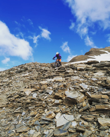
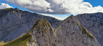
Absolutely cyclo-mountaineering tour in a grand, wild, lunar and panoramic dolomite environment, in the presence of the Queen of the Orobie Mountains, Presolana. It is normal to spot the chamois that numerous populate these places. Long and challenging backpacking sections, also on small rocks, short but difficult (with the bike on your back) section with chains to reach the Pizzo di Petto pass. Final descent trail from Ferrantino first and Albani hut later that does not suit mountain bikers, quite rough. Not recommended for eMTB.
Departure from Colere, Val di Scalve (parking at the oratory with sports field) and transfer to Teveno, almost completely avoiding asphalt along the beautiful "Talking Plants trail." From Teveno you reach Nona, passing through Pezzolo by the old steep direct road or more easily by the asphalt road. Now go up the dirt (cemented) road in the direction of Passo della Manina, 1795 meters, with a last stretch on a path. When you reach the pass, follow the signs for the Fontanamora pass and the Albani refuge (trail 401).
Past the meadow below the Sonda Vaga you have to overcome with the bike on your back a challenging rocky section. To the right makes a fine presence the isolated Spigorei horn overlooking the Sedornia Valley below. Entering the wide amphitheater between the rocky buttresses of Pizzo di Petto and the northern slope of Vigna Vaga you climb, bike strictly on your shoulders, until below the Pizzo di Petto pass. You overcome the short section equipped with chains between the rocks with great effort and attention (better to be at least two). From the vent you can climb briefly on foot to the summit, 2259 meters, to admire the grandiose panorama.
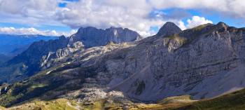
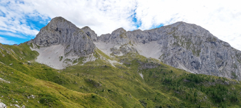
Short, beautiful descent with some technical passages, then climb back to Fontanamora Pass, 2224 meters. Still following Orobie Trail 401, we climb further, still shouldering the bike, passing a section of rocky terrain to pass the highest point of the tour, 2330 meters, just below the summit of Fontanamora, 2350 meters. Continuing to traverse with some up and down you pass along a scree ledge below the striking east face of Ferrante. Last short climb and you are just below the cusp of Ferrantino, the point where the first part of the technical descent to the Aquila hut, 2160 meters, begins. From the refuge one must now "sail" for a stretch in the "Sea in Burrasca" from the impetuous petrified waves that is nothing but a vast karst plateau, dotted with endless depressions.
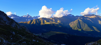
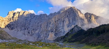
Resuming the descent from the Scagnello Pass, 2076 meters, one suddenly finds oneself in the presence of the majestic, imposing North Face of the Presolana, which in the late afternoon is illuminated by the tangent light of the sun, giving rise to a breathtaking spectacle. The Albani refuge, 1949 meters, you leave it on the left and past the building of the old mines, turning left you take the scorbutic path 403 that with a technical, physical, very challenging descent brings us back to Colere (in the lower part you have to be careful to locate it, do not descend along the track).


