HOME RANKINGS CHALLENGES ROUTES POI PLANNING SEARCH LOGIN
Italy - Valle d'Aosta, AO
2023/08/05 17:26:21

Pila - Epinel

62 Downloads
7
 
Author
Place
Italy - Valle d'Aosta, AO
Km
37,61 km
Elapsed time
03:37:25
Vertical meters
+800 mt (565 - 2674)
Route difficulty
Landscapes
Last update
2023/08/05 21:14:52
Comments
1
Description

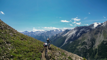
Beautiful All-Mountain tour in the Aosta area Taking advantage of the Pila ski area, we take the lifts that take us briefly up to altitude, then on a farm track we reach the beautiful ridge that divides Aosta and Cogne, from where we can admire a 360° panorama of all the surrounding Alpine peaks.

Having done the first part of the ridge, we reach the pass from where the descent trail starts, taking us down into the valley. The descent, which cuts diagonally across the whole mountain, except for a few hairpin bends, is never too technical but the whole first part is very exposed so you have to be very careful. Once in Epinel, the return to Aosta is unfortunately by necessity on asphalt except for a final piece of trail. It is a tour that I recommend to do taking advantage of the lifts given the last part of the downhill elevation gain lost on the road

NB:

  • At the time of the ride I was unable to record the correct track because the uphill track is temporarily closed for construction work on the new lift and for the closure, due to fire, of the last section of trail from Pont d'Ael down into the valley so I recommend, before leaving, to inquire from the guys at AostaValleyFreeride or at the Pila ski resort about the feasibility and possible variants.
  • Once you get off the lift at Chamolè, don't follow the trail on forestry but the Flow Trail that starts alongside on the left until the rejoin.


Download our free mobile app to send this route to your Garmin device or to navigate it on OSM maps. Android - iOS

Graph

Nearest Routes

2022/08/22
- Italy - Valle d'Aosta, AO
nonnocarb
(266)
17,77 km
Km
+1 079 mt
Vertical meters
Route difficulty
Landscapes
2023/09/12
- Italy - Valle d'Aosta, AO
ebsat
(96)
31,30 km
Km
+2 574 mt
Vertical meters
Route difficulty
Landscapes
2022/08/06
- Italy - Valle d'Aosta, AO
gmzolenart
(104)
23,17 km
Km
+1 015 mt
Vertical meters
Route difficulty
Landscapes
2022/10/24
- Italy - Valle d'Aosta, AO
69,26 km
Km
+1 967 mt
Vertical meters
Route difficulty
Landscapes
2022/09/04
- Italy - Valle d'Aosta, AO
gmzolenart
(104)
29,77 km
Km
+1 356 mt
Vertical meters
Route difficulty
Landscapes
2023/08/11
- Italy - Valle d'Aosta, AO
52,17 km
Km
+3 400 mt
Vertical meters
Route difficulty
Landscapes
2022/08/07
- Italy - Valle d'Aosta, AO
gmzolenart
(104)
30,79 km
Km
+1 471 mt
Vertical meters
Route difficulty
Landscapes
2022/09/05
- Italy - Valle d'Aosta, AO
BAROLO71
(33)
33,15 km
Km
+2 277 mt
Vertical meters
Route difficulty
Landscapes
2022/10/03
- Italy - Valle d'Aosta, AO
gmzolenart
(104)
18,80 km
Km
+1 062 mt
Vertical meters
Route difficulty
Landscapes
2022/10/04
- Italy - Valle d'Aosta, AO
gmzolenart
(104)
23,03 km
Km
+1 249 mt
Vertical meters
Route difficulty
Landscapes

1 Comments