HOME RANKINGS CHALLENGES ROUTES NEAR ME PLANNING SEARCH LOGIN
Italy - Lombardia, CO
2025/07/14 13:07:54

Cima monte Bregagno e discesa in Val Sanagra, da Rezzonico

85 Downloads
5
 
Share
Author
pedalario
(7)
Place
Italy - Lombardia, CO
Km
48,04 km
Elapsed time
00:00:00
Vertical meters
+2 440 mt (199 - 2099)
Route difficulty
Landscapes
Last update
2025/09/17 21:42:02
Comments
0
Description

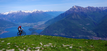
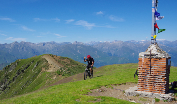
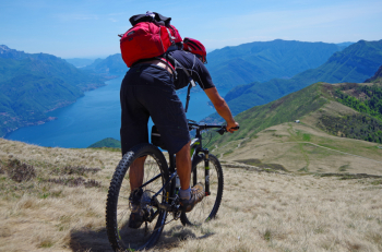
Departure from Rezzonico, ascent by asphalt road through the mountains to Montuglio locality, with small pond. Barred access to agrosilvo dirt road to Alpe Rescascia and oratory of Sant'Amate. Arrived at the plain, at an elevation of 1600 m, just above the little church, climb to the right for a minimal pedaled section, then shouldered up to Bregagnino, 1905 m, Bregagno's anticima. From here a nice false-flat pedaled section to base of summit, then shoulder again to summit at 2107m. Return by the same route as the ascent, all in the saddle on grassy slope, paying close attention to potholes and gullies.

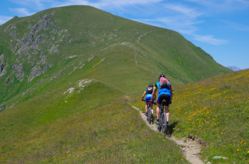
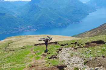
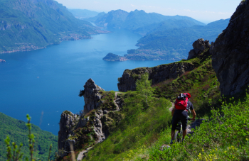
Arrived at Sant'Amate, continue on ridge to Forcoletta, base of the rocky Monta Grona; from here the trail descends to the Menaggio refuge, with spectacular views, but very steep and exposed in the intermediate section from here down to the Menaggio refuge. Not recommended: I had previously done this mostly on foot, on this round trip instead I went back to Sant'Amate, then continued on the trail to Alpe Nesdale, then down by trail to Alpe Pisnera, where the road to the mountains on the right side of Val Sanagra arrives. You descend until you find, at a bend to the right, on the left, a small temple, the oratory of San Rocco. Immediately afterwards take a forest road on the left that descends to become a path to the crossing of the Sanagra stream, and then continuing along the left bank reaches the charming village of Barna. From here again by path to Loveno, then Nobiallo, hamlets of Menaggio. The last stretch to Rezzonico along a old state highway now a bike path.

P

Download our free mobile app to send this route to your Garmin device or to navigate it on OSM maps. Android - iOS
Local weather
Thu 00:00
21 °C
Thu 12:00
22 °C
Fri 00:00
17 °C
Fri 12:00
23 °C
Sat 00:00
19 °C
Sat 12:00
18 °C
Sun 00:00
19 °C
Sun 12:00
24 °C
Mon 00:00
21 °C
Mon 12:00
25 °C

Graph

Nearest Routes

2024/12/06
- Italy - Lombardia, CO
marco
(171)
23,45 km
Km
+1 500 mt
Vertical meters
Route difficulty
Landscapes
2025/11/08
- Italy - Lombardia, CO
Staff
(108)
38,35 km
Km
+1 728 mt
Vertical meters
Route difficulty
Landscapes
2023/05/06
- Italy - Lombardia, LC
ValeBG
(171)
31,79 km
Km
+1 650 mt
Vertical meters
Route difficulty
Landscapes
2024/04/10
- Italy - Lombardia, LC
ValeBG
(171)
33,66 km
Km
+1 716 mt
Vertical meters
Route difficulty
Landscapes
2025/06/06
- Italy - Lombardia, LC
RoccoAcc
(5)
27,87 km
Km
+1 275 mt
Vertical meters
Route difficulty
Landscapes
2023/12/28
- Italy - Lombardia, CO
Staff
(108)
36,49 km
Km
+1 420 mt
Vertical meters
Route difficulty
Landscapes
2022/09/22
- Italy - Lombardia, CO
34,99 km
Km
+1 464 mt
Vertical meters
Route difficulty
Landscapes
2025/01/08
- Italy - Lombardia, CO
Staff
(108)
35,19 km
Km
+1 666 mt
Vertical meters
Route difficulty
Landscapes
2026/05/31
- Italy - Lombardia, CO
yura
(13)
35,34 km
Km
+2 200 mt
Vertical meters
Route difficulty
Landscapes
2023/01/31
- Italy - Lombardia, CO
RONKO
(2)
31,44 km
Km
+1 348 mt
Vertical meters
Route difficulty
Landscapes

0 Comments