
 Italiano
 Deutsch
Monte Pravello - Poncione D’Arzo – Rancate

Itinerary between Italy and Switzerland to discover the massif of Mount Pravello - Poncione d'Arzo. Start from the Cantello cemetery (free parking) and, limiting asphalt travel to a minimum, first reach the village of Bevera, then Viggiù and then follow the signs to Mount Orsa/Pravello. This massif is known to host numerous fortifications dating back to the period of World War I (Cadorna Line): numerous trenches, tunnels, artillery emplacements and other military structures are still visible, well preserved and open to visits.
After passing the junction to S. Elias Hill, turn right and take the former military road (paved but closed to vehicular traffic) that leads toward the summit to Mount Ursa. The gradient of the climb is never excessive (around 9 percent with a few 12 percent peaks) and you soon reach the junction to Mount Pravello (right). Here begins the last stretch of the now unpaved climb, you pass the Mount Pravello refuge (open only on Sundays and equipped with ebike charging stations) and shortly reach the summit of the mountain of the same name, just near the state border. From the summit, you can admire one of the most beautiful views of Lake Lugano, surrounded by the main peaks of the Alps (Monte Rosa, Mischabel and Weissmies, Monte Leone, Jungfrau-Fiescherhorn, Adula) and of the Pre-Alps in the area (from the Lema-Tamaro ridge to Monte Generoso).
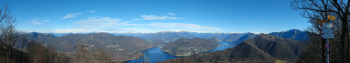
Overview from the summit of Mount Pravello
From here, after entering Swiss territory, it is a short walk to the twin summit of Poncione d'Arzo, from which the trail of the same name starts: initially very steep and dotted with outcropping rock (difficulty S2+). The most challenging section ends at a steep relaunch with subsequent passage under a pylon. From here on the trail becomes somewhat less steep, though still "crunchy," until it joins a forest road. You walk along a short section of road, then on the left you take the Cave trail (difficulty S1+): more flow and less demanding, but still characterized by the crushed stone bottom typical of this area. The trail ends at the Arzo quarries, now converted into an open-air museum. It continues for a short stretch on asphalt, then takes a connecting trail that leads, with a few rocky passages, to the vicinity of Meride, from where the last descent of the itinerary starts. This is the Acquedotto trail (difficulty S2): initially a simple double track, which then quickly turns into a very physical (but not too technical) singletrack on fixed rocks: a good test of suspension setup and tire strength! Not recommended if wet, as the stone in the area offers little grip in those conditions. The descent ends at an aqueduct building, then on to the village of Rancate and from there, up along the course of the Laveggio stream, to S. Margherita and finally to the Gaggiolo pass (practically without everything on dirt trails). From here it goes up to the Cantello cemetery via a comfortable section of bike path and a fast single track.
Itinerary traveled on 03.04.2025 with mtb
Edit 06.07.2025: modified the track to the Bevera locality due to a trail connection now no longer viable due to forestry work.


