
 Italiano
 Deutsch
Valle del Lanza

The Lanza Valley Park, which stretches along the valley crossed by the stream of the same name and traversed by the Valmorea railway (disused for many years), is known for its gravel-covered valley floor trails and the permanent Granfondo dei Longobardi route. Here, however, I propose a trail/enduro itinerary that links the most interesting descents in the area. The itinerary involves frequent border crossings between Italy and Switzerland.
The area can be easily reached by train, getting off at Malnate or Cantello/Gaggiolo stations.
The route starts from the large car park at the former Rodero railway station (destroyed years ago by a fire): after crossing the village, you enter Swiss territory for the first time via a secondary pass, and shortly afterwards the first descent begins:
- Sentiero di Sergio (difficulty S0): a flow trail that takes us to the bottom of the valley in S. Margherita, where the old railway tracks crossed the border between Italy and Switzerland near an iron gate.
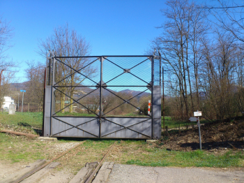
The gate marking the border between Italy and Switzerland along the old Valmorea railway (S. Margherita).
We return to Italy through a gap in the border fence and continue uphill on asphalt to the village of Bizzarone and then on cobblestones to the small church of the Assunta.
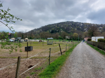
Uphill alternative for e-MTBs: after reaching the sports center parking lot, turn left and take a steep forest road that leads directly above the church, avoiding the detour around the hill. From here, a steep and uneven stretch leads to the top of the S. Ambrogio hill, where there is a panoramic terrace surmounted by a cross (however, the view is not very interesting due to invasive vegetation). From here, the longest descent of the itinerary begins:
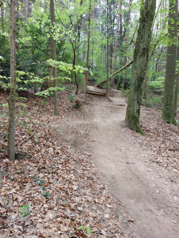
- Croce di Bizzarone (medium difficulty S1, with some S2 sections): a very varied trail that first features curves on dirt and roots, then more broken sections, small jumps, a steep section with compression, etc. CAUTION! In the second part of the descent, after a short toboggan run, the trail crosses the small asphalt road that you took earlier on the way up, which is open to vehicular traffic, so be careful when crossing! The trail ends at the bottom of the valley along the disused railway tracks.
Top of the S. Ambrogio hill (Bizzarone)
Retrace part of the previous climb to take the most technical descent in the area:
- Diretta su S. Margherita (difficulty S3): a short but challenging trail with many slow and steep turns on dirt and roots, a few small artificial drops, and other difficulties due to the clayey soil and steep slope. Absolutely not to be attempted in damp or wet conditions!
S. Margherita, with the S. Ambrogio hill in the background
Take the previous climb again to reach the trail:
- Ai boschi (medium difficulty S1, short S2 section at the end): fun flow trail on earthy ground.
Continue towards Colle S. Maffeo, from the top of which you can enjoy a beautiful view of the Olgiate area and the Prealps of the Larian Triangle. The first part of the descent is not particularly difficult, then turn right and take the trail:
- 5 luppoli (difficulty from S2 upwards depending on the line chosen): this is a sort of mini bike park with a curve with wooden support at the entrance, then a few drops, a jump line (doubles, table tops, etc.), and finally a steep section. There are lines of varying difficulty and all jumps can be avoided with a chicken line, except for one drop at the beginning. Obviously, it is recommended that you carefully assess all the obstacles you intend to tackle according to your technical abilities and the state of maintenance of the structures themselves.
Trail 5 Luppoli
Finally, continue towards the hill of Cagno, where the trail starts:
- Salamandra (difficulty S1): a short natural trail with a series of fun bends in quick succession.
From the end of the trail, return to the car park along a section of the valley floor path that runs alongside the railway tracks.
Route traveled on 04/12/2025 by MTB.


