HOME RANKINGS CHALLENGES ROUTES POI PLANNING SEARCH LOGIN
Italy - Trentino-Alto Adige/Südtirol, TN
2024/07/30 11:58:34

Val San Nicolò e val Contrin

7 Downloads
2
 
Share
Author
Staff
(72)
Place
Italy - Trentino-Alto Adige/Südtirol, TN
Km
32,71 km
Elapsed time
04:39:16
Vertical meters
+1 088 mt (1300 - 2330)
Route difficulty
Landscapes
Last update
2024/07/30 14:13:00
Comments
1
Description

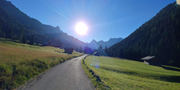
Route with about 1 hour of biking to cover the 350 meters of elevation gain on the trail to the San Nicolò Pass. Depart from Mazzin and ride the easy dirt bike path along the Avisio to the village of Pozza di Fassa. Once in Pozza take the paved road that leads into the San Nicolò valley. After a short while I recommend leaving the asphalt to try your hand at the cart track with a few hard climbs that flank the asphalt, at least you will warm up. You ride all along the beautiful valley, at the end of the valley keep left on the cartroad (which became unpaved at a certain point) and then carry the bike as mentioned in the opening.

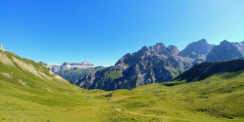
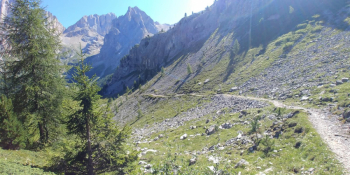
The bottom is bumpy and unstable and the gradient is absurd. it is only 350 meters of elevation gain but it is tiring. Arriving at the pass you will enjoy a wonderful view, the Graan Vernel, the south face of the Marmolada. Possibility of refreshment at the San Nicolò pass refuge, the cakes are worth the sweat and it is wonderfully located. The descent is doable all in the saddle for those with good technical skills. Until the Contrin refuge it is a technical single track with some challenging sections, then it becomes a wide and very fast cartroad. In summer there are a lot of hikers on foot on the trail, be careful!

Traveled all the way down the Contrin Valley you will reach Alba di Canazei and there take the Avisio bike path to the starting point.


Download our free mobile app to send this route to your Garmin device or to navigate it on OSM maps. Android - iOS
Local weather
°C
°C
°C
°C
°C
°C
°C
°C
°C
°C

Graph

Nearest Routes

2023/08/22
- Italy - Trentino-Alto Adige/Südtirol, TN
Robibz
(19)
38,66 km
Km
+1 695 mt
Vertical meters
Route difficulty
Landscapes
2023/03/06
- Italy - Trentino-Alto Adige/Südtirol, TN
nonnocarb
(284)
20,80 km
Km
+1 120 mt
Vertical meters
Route difficulty
Landscapes
2023/01/12
- Italy - Trentino-Alto Adige/Südtirol, TN
Seraffo85
(13)
29,35 km
Km
+1 200 mt
Vertical meters
Route difficulty
Landscapes
2022/08/19
- Italy - Trentino-Alto Adige/Südtirol, TN
pozzoligio
(93)
51,42 km
Km
+2 048 mt
Vertical meters
Route difficulty
Landscapes
2022/08/20
- Italy - Trentino-Alto Adige/Südtirol, TN
pozzoligio
(93)
28,10 km
Km
+791 mt
Vertical meters
Route difficulty
Landscapes
2024/07/12
- Italy - Trentino-Alto Adige/Südtirol, TN
31,65 km
Km
+1 250 mt
Vertical meters
Route difficulty
Landscapes
2022/10/22
- Italy - Trentino-Alto Adige/Südtirol, TN
nonnocarb
(284)
41,88 km
Km
+2 190 mt
Vertical meters
Route difficulty
Landscapes
2023/02/26
- Italy - Trentino-Alto Adige/Südtirol, TN
nonnocarb
(284)
24,50 km
Km
+1 500 mt
Vertical meters
Route difficulty
Landscapes
2023/07/28
- Italy - Trentino-Alto Adige/Südtirol, TN
pozzoligio
(93)
35,59 km
Km
+1 551 mt
Vertical meters
Route difficulty
Landscapes
2023/07/27
- Italy - Trentino-Alto Adige/Südtirol, TN
pozzoligio
(93)
47,84 km
Km
+2 292 mt
Vertical meters
Route difficulty
Landscapes

1 Comments