HOME RANKINGS CHALLENGES ROUTES NEAR ME PLANNING SEARCH LOGIN
Italy - Toscana, FI
2023/11/27 12:09:37

Giro dell'Abbraccio e Giogarello

2 Downloads
0
 
Share
Author
Tonweya
(1)
Place
Italy - Toscana, FI
Km
41,40 km
Elapsed time
06:07:30
Vertical meters
+1 650 mt (361 - 1097)
Route difficulty
Landscapes
Last update
2023/11/27 15:49:48
Comments
0
Description

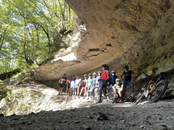
Challenging route by mountain bike, preferably by e-mountain bike, although between Abbraccio Waterfall and Rifugio i Diacci there is a semi-natural staircase on which you have to put no small amount of effort to bring the bike up. Otherwise everything is rideable.

The trail starts from San Pellegrino, a hamlet of Firenzuola. Initial section on asphalt, then hard climb initially paved, then on rough terrain. Easy descent to Badia di Moscheta, where refreshments and water are available. Uphill on challenging gravel road to Giogarello, then uphill again on uneven trail. Arrived at a scenic point, descend (challenging) to Rifugio La Serra (water), from here long stretch on gravel road to Capanna Marcone, then descent, at times hostile to Mulino dei Diacci, then past Cascata dell'Abbraccio uphill stretch with bike on shoulder or otherwise to push along bumpy steps.

At the i Diacci refuge possibility of refreshment and water, then a long climb on gravel, then at the parking lot turn left and enter the woods above the Senio Valley first and then the Santerno. After a long up and down stretch a long challenging descent leads to Casetta di Tiara, from here on asphalt first downhill then flat you return to the starting point.
Download our free mobile app to send this route to your Garmin device or to navigate it on OSM maps. Android - iOS
Local weather
Tonight
1 °C
Tomorrow
7 °C
Tomorrow night
0 °C
Monday
6 °C
Monday night
0 °C
Tuesday
8 °C
Tuesday night
1 °C
Wednesday
7 °C
Wednesday night
1 °C
Thursday
6 °C

Graph

Nearest Routes

2023/01/09
- Italy - Toscana, FI
ebsat
(109)
36,13 km
Km
+1 387 mt
Vertical meters
Route difficulty
Landscapes
2024/02/04
- Italy - Toscana, FI
ebsat
(109)
33,12 km
Km
+1 584 mt
Vertical meters
Route difficulty
Landscapes
2023/01/08
- Italy - Toscana, FI
ebsat
(109)
29,01 km
Km
+1 233 mt
Vertical meters
Route difficulty
Landscapes
2023/07/06
- Italy - Toscana, FI
ebsat
(109)
32,74 km
Km
+1 470 mt
Vertical meters
Route difficulty
Landscapes
2024/12/01
- Italy - Toscana, FI
ebsat
(109)
38,16 km
Km
+1 477 mt
Vertical meters
Route difficulty
Landscapes
2024/03/24
- Italy - Toscana, FI
ebsat
(109)
35,62 km
Km
+1 239 mt
Vertical meters
Route difficulty
Landscapes
2024/10/17
- Italy - Toscana, FI
Paoloc1
(66)
39,00 km
Km
+1 600 mt
Vertical meters
Route difficulty
Landscapes
2024/03/15
- Italy - Toscana, FI
Paoloc1
(66)
37,47 km
Km
+1 348 mt
Vertical meters
Route difficulty
Landscapes
2023/10/28
- Italy - Toscana, FI
Paoloc1
(66)
25,10 km
Km
+1 000 mt
Vertical meters
Route difficulty
Landscapes
2024/12/07
- Italy - Toscana, FI
Paoloc1
(66)
32,50 km
Km
+1 400 mt
Vertical meters
Route difficulty
Landscapes

0 Comments