Italiano
 Deutsch
Archetta Monte Colonna e sentiero Cai 527

Parked the car in Ronta in a large square near the Carabinieri barracks we go up on asphalt in the direction of Passo della Colla di Casaglia passing through Madonna dei tre Fiumi and Razzuolo. Arriving at the pass we turn right towards Palazzuolo sul Senio until we get to the drainage near Prato all'albero.
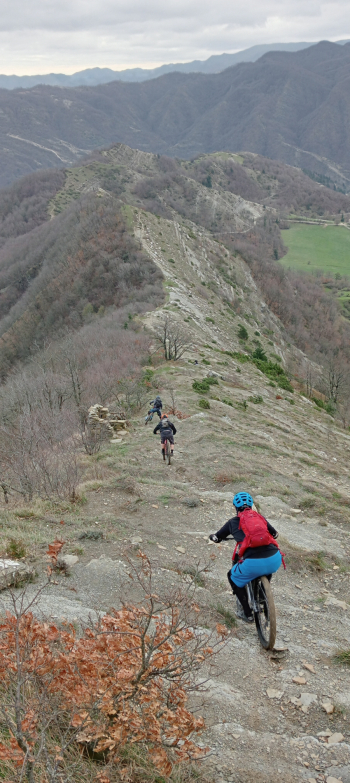
Abandoning the asphalt we continue into the wonderful Mugello woods following the CAI 505A/505 trail to the point where it intersects with the 531. From here we will begin the first descent on the ridge of Monte Archetta very scenic technical that has its highlight in the very steep section that today I overcome brilliantly giving indication of the passage to those behind me. Arriving at the Hunters' hut we continue to the right always on CAI path 531 always on technical trail that leaves no room for distractions.
Arrived in the vicinity of Mount Colonna short bike ride to conquer its summit and then return just below to resume the pedalable trail since from the summit to continue, as I remembered well, there would be rock jumps to overcome that are only feasible with the bike handrail. Having recovered the pedalable part of the trail, the music does not change and the trail remains very enjoyable all the way to Crespino sul Lamone.
From the latter we recover the CAI 527 trail that with borderline inclines forces us to push the bike also because after the rains of the past few days the road today in some sections is literally a sticky mush. Having passed poggio di Valdosera we begin the descent of the Faldi always on CAI trail 527.
The trail is easier than the previous one less technical and faster, but today it is practically soaked and slimy consequently we face it with due catela. Arrived at the sports field of Biforco we head to Marradi where via Train we return to Ronta.
Very enjoyable ride definitely to be replicated in dry conditions perhaps varying the first descent with the Crinale di punta Zannella.
Done on 07/01/23