HOME RANKINGS CHALLENGES ROUTES POI PLANNING SEARCH LOGIN
Italy - Trentino-Alto Adige/Südtirol, TN
2023/06/29 20:18:11

Sulle creste del Lagorai

93 Downloads
0
 
Author
Place
Italy - Trentino-Alto Adige/Südtirol, TN
Km
60,06 km
Elapsed time
07:59:27
Vertical meters
+3 200 mt (741 - 2330)
Route difficulty
Landscapes
Last update
2023/06/30 07:40:43
Comments
0
Description

Nice tour in the Lagorai that I decided to split in two days to spend a night in bivouac.

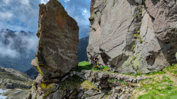
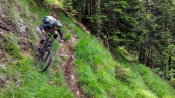
First day nice intense and hard given the more than 2000 meters of elevation gain with nice loaded backpacks. We climb to the Manghen pass and from there we continue on a nice path sometimes cyclable sometimes not until we reach Mount Val Piana from where the descent begins, at first very steep with some technical passages to then become a flow on meadows and woods. The trail ends at Malga Cere and from there unfortunately you reach the Campelle valley on forestry because the descent trail after the Vaia storm no longer exists. From the Sat Lagorai hut you continue to the 5 Croci pass from where you then descend to the Nassere bivouac (alternatively you can reach it immediately avoiding going up to the pass).

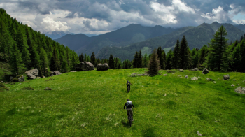
The second day will occupy you only the morning, shorter tour of about 1200 meters of elevation gain. You start from the bivouac and climb to Forcella Rava (400 meters of backpacking bike), then in a southerly direction you reach the Argentino bivouac from where the final descent begins, the first part a bit wild with loose stones then on very flowing forest. When you reach Samone you return to the starting point with another bit of ascent and a last short very vertical trail starting from the Cruccolo refuge (ask the refuge if it is practicable, sometimes I found it in very bad conditions and closed by vegetation)

Many footholds on the whole tour. Water is always found except in the ridge section between forcella Ziolera and cima val Piana and in the last ridge section between forcella Rava and forcella del Dogo.

Download our free mobile app to send this route to your Garmin device or to navigate it on OSM maps. Android - iOS

Graph

Nearest Routes

2023/07/06
- Italy - Trentino-Alto Adige/Südtirol, TN
miciolo
(28)
25,18 km
Km
+1 310 mt
Vertical meters
Route difficulty
Landscapes
2023/07/31
- Italy - Trentino-Alto Adige/Südtirol, TN
30,70 km
Km
+1 450 mt
Vertical meters
Route difficulty
Landscapes
2022/10/09
- Italy - Trentino-Alto Adige/Südtirol, TN
marco
(102)
34,48 km
Km
+1 457 mt
Vertical meters
Route difficulty
Landscapes
2023/08/29
- Italy - Trentino-Alto Adige/Südtirol, TN
Scc
(2)
47,89 km
Km
+2 166 mt
Vertical meters
Route difficulty
Landscapes
2022/08/16
- Italy - Trentino-Alto Adige/Südtirol, TN
gaspa91
(4)
17,79 km
Km
+929 mt
Vertical meters
Route difficulty
Landscapes
2022/11/19
- Italy - Trentino-Alto Adige/Südtirol, TN
58,20 km
Km
+3 100 mt
Vertical meters
Route difficulty
Landscapes
2024/02/15
- Italy - Trentino-Alto Adige/Südtirol, TN
21,53 km
Km
+1 150 mt
Vertical meters
Route difficulty
Landscapes
2023/02/06
- Italy - Trentino-Alto Adige/Südtirol, BZ
nonnocarb
(266)
35,36 km
Km
+1 065 mt
Vertical meters
Route difficulty
Landscapes
2023/07/06
- Italy - Trentino-Alto Adige/Südtirol, TN
26,58 km
Km
+600 mt
Vertical meters
Route difficulty
Landscapes
2023/07/11
- Italy - Trentino-Alto Adige/Südtirol, TN
27,71 km
Km
+1 560 mt
Vertical meters
Route difficulty
Landscapes

0 Comments