HOME RANKINGS CHALLENGES ROUTES POI PLANNING SEARCH LOGIN
Italy - Trentino-Alto Adige/Südtirol, BZ
2023/06/19 13:57:52

Raciesa e monte Pic

49 Downloads
4
 
Author
Place
Italy - Trentino-Alto Adige/Südtirol, BZ
Km
28,19 km
Elapsed time
04:33:45
Vertical meters
+1 800 mt (1220 - 2329)
Route difficulty
Landscapes
Last update
2023/06/19 14:05:39
Comments
0
Description

Very nice tour, very scenic but very hard both for the climbs and the final descent

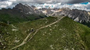
We start from Ortisei and right from the start we start a very steep climb that leads to the top of Mount Raciesa where you can enjoy an excellent view of all the Dolomites

From here starts the first descent mainly flow and never too technical that first along a nice ridge and then on fun trail over forest leads to the middle station of Seceda. The only thing you have to pay a lot of attention to is pedestrians, it is a very busy trail so you have to remain very vigilant and always give right of way

Last little piece is forbidden to bikes, in case follow the forestry trail that runs parallel

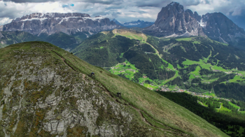
From the Seceda lift you can go up either by cable car (open only in season) or by the very hard ski slope, arrived at the fork short shoulder to Mount Pic, another super panoramic peak.

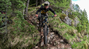
From here starts the final descent where the first part is on an epic ridge, and the second part is on a trail with very technical passages, to be faced only if in possession of a very good driving technique or pushing the bike. As you descend the trail gradually becomes more "human" but never mundane. Not to be done in wet weather!


Download our free mobile app to send this route to your Garmin device or to navigate it on OSM maps. Android - iOS

Graph

Nearest Routes

2023/02/25
- Italy - Trentino-Alto Adige/Südtirol, BZ
nonnocarb
(266)
30,60 km
Km
+1 250 mt
Vertical meters
Route difficulty
Landscapes
2023/02/20
- Italy - Trentino-Alto Adige/Südtirol, BZ
nonnocarb
(266)
19,26 km
Km
+966 mt
Vertical meters
Route difficulty
Landscapes
2023/02/26
- Italy - Trentino-Alto Adige/Südtirol, BZ
nonnocarb
(266)
37,25 km
Km
+1 350 mt
Vertical meters
Route difficulty
Landscapes
2023/03/04
- Italy - Trentino-Alto Adige/Südtirol, BZ
nonnocarb
(266)
35,57 km
Km
+2 000 mt
Vertical meters
Route difficulty
Landscapes
2023/02/26
- Italy - Trentino-Alto Adige/Südtirol, BZ
nonnocarb
(266)
44,97 km
Km
+1 590 mt
Vertical meters
Route difficulty
Landscapes
2023/09/14
- Italy - Trentino-Alto Adige/Südtirol, BZ
58,55 km
Km
0 mt
Vertical meters
Route difficulty
Landscapes
2023/01/31
- Italy - Trentino-Alto Adige/Südtirol, BZ
nonnocarb
(266)
28,18 km
Km
+1 467 mt
Vertical meters
Route difficulty
Landscapes
2022/11/01
- Italy - Trentino-Alto Adige/Südtirol, BZ
nonnocarb
(266)
51,53 km
Km
+2 551 mt
Vertical meters
Route difficulty
Landscapes
2023/02/26
- Italy - Trentino-Alto Adige/Südtirol, BZ
nonnocarb
(266)
18,78 km
Km
+820 mt
Vertical meters
Route difficulty
Landscapes
2022/12/25
- Italy - Trentino-Alto Adige/Südtirol, BZ
nonnocarb
(266)
24,88 km
Km
+1 140 mt
Vertical meters
Route difficulty
Landscapes

0 Comments