
 Italiano
 Deutsch
Il San Primo e i suoi Fratelli
Where is St. First's? And most importantly, who are its brothers?
"Mount San Primo is a Lombardy mountain located in the Comasche Pre-Alps, rising to an elevation of 1,682 m a.s.l. This relief in the province of Como is the highest peak in the Larian triangle and overlooks the shores of Lake Como and Bellagio. Although it is not among the highest peaks in the Alps, it dominates a spectacular panorama. In fact, given its particular geographical location and altitude, it offers a very beautiful view of Lake Como, the Alps, the Comasche Pre-Alps, and, on extremely clear days, a part of the northern Apennines. For this very reason, it is considered the most scenic mountain in the whole area between Como and Lecco."
What about its Brothers? Let's get to know them.
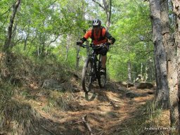
The itinerary begins in the municipality of Asso, where from the convenient free parking lot we set off to face the first and long climb to the conquest of Cima del San Primo. On asphalt road we reach Caglio where, after a steep climb, we switch to dirt road crossing a beautiful chestnut grove and a beautiful pine forest; towards the end the dirt road becomes an easy path that with beautiful views takes us to the Colma di Caglio and shortly to the well known Colma di Sormano altitude 1130mt by the cousins of the road bikers. Just past a bend after a bar starts the long dirt/cemented path that with beautiful views leads us first to Colma del Bosco and then to Bocchetta di Spessola altitude 1245mt.
Now begins the hard cemented climb gladdened by the beautiful views of the Piana del Tivano below that takes us to Bocchetta di Terrabiotta 1430mt. We refit and enjoy the beautiful view of Bellagio. We set off again, still on a dirt road, along the long eat-and-drink ridge that cuts the San Primo side.
We then arrive at the attack of the trail that with a short shoulder takes us to the 1682mt. summit of S.Primo.
After contemplating the place, we now face the long descent, initially on the beautiful East Ridge, which, with a couple of push relaunches, brings us back to Terrabiotta. A short stretch back on the cemented road made to climb where at the first hairpin bend we take the path marked Pian Rancio; and right there we arrive after an exciting descent first panoramic on the coast then fast and rocky in the woods.Super!
All we have to do is to ascend again with discrete effort to Rifugio Martina, which we omit, to enter the so-called Dorsale Trail to Cresta. A beautiful singletrack that will lead us, tending to descend, passing through Monte Fopà the Bocchetta di Lezzeno to the Bocchetta del Nuvolone.
Monte Nuvolone, Last important peak 1190mt of the Cresta before the dry descent to Bellagio. Mah we are not interested in the Cima, inciclable, but in its Belvedere that will be reached on the narrow path that goes around the mountain of the same name.
The trail begins to climb sharply, the more trained will saddle it qausely all the way up to the Grotto containing the Madonna dei Fungiàt who will bless the local mushroomers, but we are not interested in the mushrooms but in the obvious wall of rock and roots that we have to face. Bikes on our shoulders and with the Madonna behind us we climb with considerable effort until it becomes rideable again.
Beautiful path and the view opens in what is defined by a Plaque affixed to a rock: "el post pù se bèl del mund". Hyper panoramic viewpoint overlooking Isola Comacina the Monte Crocione and all the other wonders are in front of us.
Refreshing break protections and descent ON. Much attention to the first steep section then total enjoyment until Brogno. Challenging trail that alternates between very flowing sections intevalled by not idifferent technical passages. Spectacular!!!
In Brogno, yes, it is necessary to climb again. Briefly on the busy State Road, ocio, Valassina then in the fascinating Via Mora surrounded by Villas and parks of remarkable beauty.
But that's not all, upon arrival on the asphalt road that climbs from Magreglio to Pian Rancio, you have to go up with a few hairpin bends also dirt road to raggiure the beautiful Pineta del Monte Corbera and its Panoramic Point the Croce di Dalco. More contemplation of the view and down on the trail called Dalco-Cross-Castagneti, not very long but very enjoyable. WOW!
We thus arrive at Magreglio Birretta Caffe Gelato, each his own and we are ready to tackle the last part of the long route.
The trail, still in climbing mode, takes us to the Pra Giorgio and La Bolla area where the fun Lambro Trail shortly leads us to the road up from Barni. We climb a little more and take on the left a not very evident little road path that, avoiding a paved piece, takes us to that of Crezzo.
We are at the slopes of the wooded and modest Mount Megna. We briefly climb the path and, still on the same, at the beginning of a beautiful and long descent. Fantastic!
In the last part it becomes a fascinating muletrack shredding arms; too bad that the Spring with its jumps of Water was completely dry, we are in Maisano.
Now passing through the Borghi della zona, Maisano Osigo Visino crossing the characteristic little streets and secondary paths, a short ascent on a 15% mule track awaits us where at the end we catch a glimpse of the Asso Parking from where we started. Watch out for the 'crossing of the state highway! But look well on your RIGHT: the Derby Live Brewery will relieve your fatigues with an excellent Beer, maybe even
NB: long and strenuous ride suitable for trained and experienced bikers.


