
 Italiano
 Deutsch
Ramaceto cresta Sud est

Splendid itinerary that allows you to ride entirely in the saddle the beautiful SouthEast ridge of Mount Ramaceto for a total elevation gain of about 1,000 m. The price to pay is a stretch of about 1.5 km (250 meters of elevation gain) for many stretches of pushing.
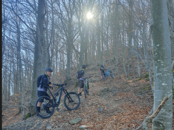
We started from Mezzanego, to reduce time and leg, but those who have any can easily start from the east Ligurian coast, Chiavari/Lavagna, and add about 25 km (a/r) and 100 m of elevation gain. You take the valley floor road towards Borzonasca, and after about 3 km turn sn towards Belpiano/Acero. Pleasant ascent on asphalt, very scenic road with very little traffic. After passing the small village of Acero, now at altitude, take sn for the Crocetta pass, first on asphalt then on dirt road. When you reach the pass, take sn on a steeply sloping cobblestone road, which soon becomes a dirt road. We have entered the Alta Via (AV) dei Monti Liguri, which we will follow to the ridge. After a few hundred meters beware that you need to leave the dirt road and take the AV following it to the ridge. The trail is entirely in beech forest, with many pushing parts.
Once on the ridge (1250 meters), the panorama opens up with spectacular views of the Ramaceto amphitheater, the Ligurian sea (frequent to see Corsica), Apuane and Maritime Alps.
Here the spectacle begins: about 1000 of elevation gain for much of it on the spectacular ridge, with a few raises, to pass some secondary peaks, the main one being Monte Cucco (a few minutes push, cross at the summit).
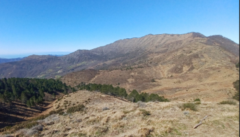
Panorama from Monte Cucco toward Monte Ramaceto (above) and from the opposite side. Clearly visible the ridge trail that we are going to follow.
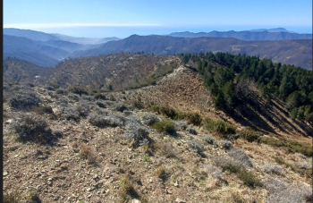
A few hundred meters after the Cucco beware that it is necessary to overcome on foot some small rocky jumps, however never exposed. Between Monte delle Groppe and Monte Azzarino, just before an electric pylon, recommended to leave the ridge (little beaten and presence of dog rose) and descend to the houses below.
Reaching the asphalt, turn left, after a few meters the road ends but behind the farmstead begins a grassy road, probably serving the power line pylons, which takes us back to the ridge. Continuing to descend, the path runs mostly through the woods until it reaches a dirt road on the northern slope. At this point you can follow it uphill (to the right) and rejoin the ridge trail, or downhill, as we did. After three switchbacks take the small road to the right, which immediately becomes a path after the farmstead. Follow the whole path halfway up the hillside to the asphalt road. By road we then do the last 200 m of elevation gain leading to the valley floor. The descent along the ridge basically follows the Mezzanego Ramaceto trail, a description of which can be found here(https://www.appenninista.it/mezzanego-ramaceto/). Not recommended in hot months due to possible presence of vegetation and little water, particularly in the section after Monte Cucco.


