
 Italiano
 Deutsch
Epico Borzonasca

Epic ride as the name suggests, you start in Borzonasca, climb the Maggiorasca and return to Borzonasca. For the daredevils, you can lengthen it by about 40 km and a 300 m elevation gain starting from the sea, Chiavari or Lavagna, however, it is all extra asphalt. The start is near the cemetery, where there is a convenient parking lot.
You go up on asphalt toward Perlezzi, take the left fork to the Malga and the asphalt becomes dirt. Continue on dirt road past the malga and over Lake Giacopiane where we will pass later.
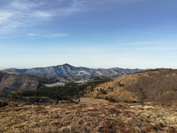
We continue on dirt road that now lets us breathe and when we arrive at the fork after a short descent we take a left again uphill. We arrive near the Pratomollo refuge, it has recently changed management, in summer it is usually always open, great if you want to stop for something to eat. Resume the climb following for the Spingarda pass, from there go downhill and at the fork take a left, after a false flat on the left starts a singletrack that will lead you to the Penna barracks, again a good place to stop, also there are several fountains. Continue on asphalt until you reach Passo del Chiodo, where you take a left towards Passo del Tomarlo. You can avoid the asphalt by following the path that runs along it, but the last stretch of asphalt going up to Tomarlo is not climbable. When you reach the pass turn right and then continue on the main road, after about 1 km take the cement road on the left, remember to close the gate. Follow this cemented road to Prato Grande and take the path leading to the saddle between the Ox and the Maggiorasca. You reach the summit, 1800 meters, the highest in the northern Apennines. Required photo.
You descend toward Tomarlo Pass on the path that proceeds on level ground; do not take the one that descends immediately below the statue because it is not cyclable. Go down a piece and then back up to Rocca del Prete and then the meadow of the Onion where you find the refuge of the same name and a very fresh water source. Descend toward Santo Stefano on one of the biek park trails, I recommend 1 or 2 to save energy, very nice and technical just right with over 2000 meters in your legs. Almost at the end of the descent take the cross-country trail on the left to Hare Pass and then continue there until you rejoin the road taken in the morning, then back to Chiodo Pass and barracks. Here you take the dirt road on the left and not the single track, to still return from the King of Cups as before. Instead of going up to the Spingarda you go up the Cereghetto and take the A2 trail that goes all the way up the north side of the Aiona, small detour on the rapid Muggetto trail and you find yourself at the Lame pass. You take the dirt road to the left and after a short while follow the arrows on the right that will guide you to Lake Giacopiane, seen a few hours earlier. You cross the dam and descend on asphalt, take the last path on the left, be careful to follow the trail well and you will find yourself after a transfer on asphalt on the first climb of the day, face it downhill and return to Borzonasca.


