
 Italiano
 Deutsch
Giro Bacci

Route of the mtb rally.
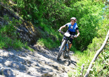
The start is from San Colombano Certenoli, there is room to leave the cars. Leaving the village take the state road to the right and then right again over the bridge and into the hamlet of Scaruglia, where you take a right and ride along the Lavagna stream on a secondary road. At the junction for Leivi continue straight on, always skirting the river, until you come to the junction for the Calvari XC course, follow it to the track and the road becomes dirt. You continue uphill on dirt road and when it ends you take a right uphill towards Villa Oneto, at the next fork you take another right and continue on asphalt until you reach the restaurant il Galletto. Here continue to the first hairpin bend where the Anchetta trail starts on the left. You follow the trail being careful at the top to choose the right lines among the many present. After a few passages on fixed rock, here I am immortalized at the dawn of my MTB adventure, at Bacci in 2016 (lycra and two fingers on the brake, never again).
Be careful to take the left turn as soon as the trail opens, you have to make a sharp turn and follow the trail back for a few dozen meters on level ground. The trail is marked, however at the first fork you take a left and then at the second follow the signs to the left for the hard, steep part with three tight but doable switchbacks. At the end you come out on cemented road and follow it to the small bridge, cross it and on the asphalt turn left towards Leivi. The asphalt comes out of the gymnasium, take a left and you will reach Bocco di Leivi, where you turn right. Before the church of San Rufino you take a left onto a cemented road, at the end of the tear you turn right and follow the signs for the 5-tower trail. You will then come to a hill, descend to the left a few meters and then take a right downhill dirt road, which turns into a fast path. At the first fork we follow the path on the right that descends towards the valley, we come to a clearing where two trail tracks start on the left, joining later, we follow the ABBRACCIALBERI, the right track. On the left, the alternative is ABBRACCIALBERI 2. We thus arrive at a picnic area, cross the small wooden bridge and take a right, returning to Scaruglia and then to San Colombano.


