
 Italiano
 Deutsch
Passo della Gava e i Ruggi - Il magico mondo della Val Lerone

The Beigua Park area and in particular La Val Lerone are magical places for mtb thanks to the special natural environment and the numerous paths both natural and lately also built specifically for mtb, thus satisfying the most varied tastes.
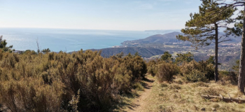
Departure from the Muvida parking lot, headquarters of the Park Authority. We descend a little on asphalt to go up the steep climb just before the Sant. Bambino di Praga, at the fourth hairpin bend we take the wide Sentiero degli Inglesi that climbs steadily and at times technical and challenging to the picnic area of Curlo.
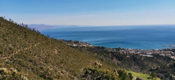
Already here a breathtaking panorama, we now begin the dirt road that we follow in its entirety as far as P.sso della Gava overlooking Genoa.
Those who wish to lengthen the tour I recommend climbing to M. Tardia and then descending to P.sso Gavetta and returning to the Gava.
We descend to the Rif. della Gava below and return to the dirt road below to take the path from the fire pit. Immediately very fun with a series of hairpin bends we are on path "A" now slightly downhill on a track that is always quite narrow but very fun and fast with a few more rocky sections.
Arrived at a clearing with rocky " U Gruppo" we continue on the right downhill now more rocky with fixed and moving stones until we arrive on wider path. We reverse direction and go along the valley on the path that is now flat and is easy to pedal but requires attention because it is exposed. The further you go the narrower it gets until it forces you to descend in some places to avoid touching with your handlebars and flying down below. Past a small bridge a short push climb brings us to the beginning of the most challenging descent of the day.
We start on a barely noticeable section between grass and rock, then after a hairpin turn the very challenging fixed rock rumba begins with two more hairpin turns that take us fording the creek in beautiful surroundings. A very technical climb to ride takes us back onto beautiful flat trail, then a short very hard ramp at the end of which we leave the flat trail to take a slightly uphill one that takes us back onto a wider trail.
We now follow the main path slightly downhill, ignoring several tracks that descend until we take a bumpy climb on the left that bypasses a ridge, soon becoming a path that forces a push section to reach, on the left, a clearing near a saddle.
We climb pedaling hard up to the summit of Bric Cravo where our very nice Hard Bird trail begins (keep left, on the right sent. Gondone), not too difficult but very fun and always to be ridden carefully because unlike the other trails being worked for mtb it is on more friable ground.
Having reached the dirt road below at a crossroads, we descend straight down the ridge, thus beginning the Farmer's Path, also similar to the previous one but less steep except at the end with a series of difficult curves that bowl us over the asphalt. All that remains is to descend to the starting point.


