2023/03/04 09:06:09
Sentieri da Merano alla bassa val Venosta
Author
Place
Italy - Trentino-Alto Adige/Südtirol, BZ
Km
47,13 km
Elapsed time
04:40:13
Vertical meters
+1 100 mt (298 - 702)
Route difficulty
Landscapes
Last update
2023/03/04 18:45:04
Comments
Description
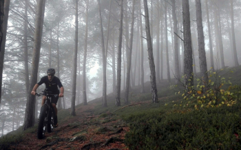
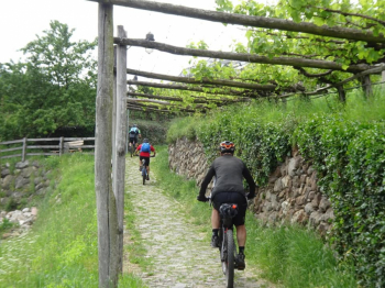
All trails possible from Merano to Naturno and then to Tirolo, the route is almost completely rideable with e-bike, with normal bike some uphill sections are very steep and you will need to push depending on ability.

Beautiful views of the high peaks of Val Venosta and around Merano. Route for experienced and trained bikers.

Local weather

°C

°C

°C

°C

°C

°C
Graph
Nearest Routes
44,14 km
Km
+2 100 mt
Vertical meters
Route difficulty
Landscapes
2024/09/04
- Italy - Trentino-Alto Adige/Südtirol, BZ 64,42 km
Km
+1 900 mt
Vertical meters
Route difficulty
Landscapes
71,62 km
Km
+1 820 mt
Vertical meters
Route difficulty
Landscapes
2023/02/26
- Italy - Trentino-Alto Adige/Südtirol, BZ 48,20 km
Km
+1 800 mt
Vertical meters
Route difficulty
Landscapes
36,69 km
Km
+1 310 mt
Vertical meters
Route difficulty
Landscapes
37,99 km
Km
+1 520 mt
Vertical meters
Route difficulty
Landscapes
48,57 km
Km
+1 550 mt
Vertical meters
Route difficulty
Landscapes
2024/09/18
- Italy - Trentino-Alto Adige/Südtirol, BZ 56,20 km
Km
+2 300 mt
Vertical meters
Route difficulty
Landscapes
51,00 km
Km
+1 610 mt
Vertical meters
Route difficulty
Landscapes
105,14 km
Km
+3 200 mt
Vertical meters
Route difficulty
Landscapes


 Italiano
 Deutsch