HOME RANKINGS CHALLENGES ROUTES NEAR ME PLANNING SEARCH LOGIN
Italy - Trentino-Alto Adige/Südtirol, BZ
2023/03/01 10:55:38

Sentieri enduro fra Terlano e Meltina

4 Downloads
1
 
Share

Key Takeaways / Scheda Tecnica

Disciplina:
Mountain Bike (MTB)
Percorso:
Sentieri enduro fra Terlano e Meltina
Località:
Italy - Trentino-Alto Adige/Südtirol, BZ
Distanza:
69,97 km
Dislivello Positivo:
+1 740 mt (Quota Min: 245m - Max: 1040m)
Difficoltà Tecnica:
4/5
Valutazione Panorami:
3/5
Formato Traccia:
GPX Download disponibile
Author
nonnocarb
(324)
Place
Italy - Trentino-Alto Adige/Südtirol, BZ
Km
69,97 km
Elapsed time
10:01:35
Vertical meters
+1 740 mt (245 - 1040)
Route difficulty
Landscapes
Last update
2023/03/01 17:17:44
Comments
0
Description

Very challenging but also very fun and scenic route, to be done by e-bike since some uphill trails are too steep to do with regular mtb. It is good to have a very good riding technique both uphill and downhill given the difficulty of the trails.
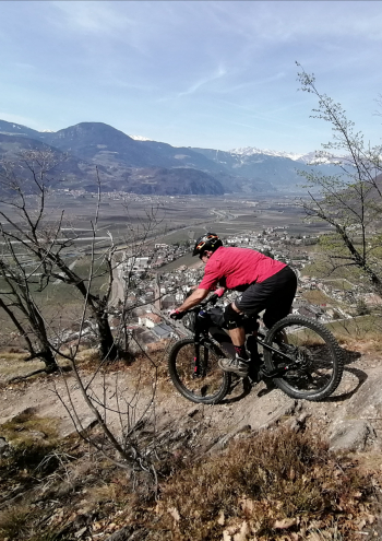
Foto itinerario MTB Sentieri enduro fra Terlano e Meltina - Italy - Trentino-Alto Adige/Südtirol, BZ

If you want to shorten the route, instead of starting from Merano you can start from Terlano or Vilpiano.

From Terlano you climb first on asphalt and then on the old Monticolo trail, which is paved and very steep (ebike only). You descend to Terlan Castle and then climb to Meltina.
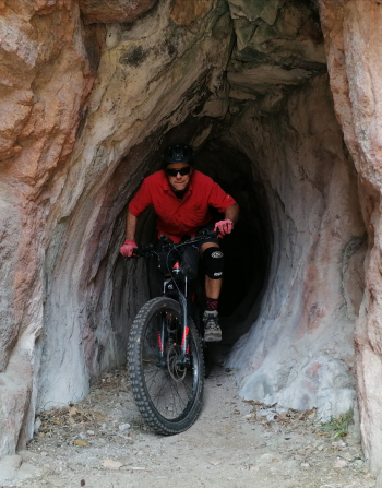
Foto itinerario MTB Sentieri enduro fra Terlano e Meltina - Italy - Trentino-Alto Adige/Südtirol, BZ

You take the downhill path to Planatsch, then climb again on the old road to Meltina. After Vallesina you take the path to the Meltina cable car and descend to the ridge below the cable car. Eventually you take the challenging path to Vilpiano and return to Merano by bike path.

Foto itinerario MTB Sentieri enduro fra Terlano e Meltina - Italy - Trentino-Alto Adige/Südtirol, BZ

Download our free mobile app to send this route to your Garmin device or to navigate it on OSM maps. Android - iOS
Local weather
Tue 00:00
15 °C
Tue 12:00
17 °C
Wed 00:00
15 °C
Wed 12:00
14 °C
Thu 00:00
13 °C
Thu 12:00
15 °C
Fri 00:00
10 °C
Fri 12:00
12 °C
Sat 00:00
10 °C
Sat 12:00
13 °C

Graph

Nearest Routes

2023/03/04
- Italy - Trentino-Alto Adige/Südtirol, BZ
nonnocarb
(324)
96,84 km
Km
+2 220 mt
Vertical meters
Route difficulty
Landscapes
2024/07/25
- Italy - Trentino-Alto Adige/Südtirol, BZ
nonnocarb
(324)
81,06 km
Km
+2 150 mt
Vertical meters
Route difficulty
Landscapes
2023/02/26
- Italy - Trentino-Alto Adige/Südtirol, BZ
nonnocarb
(324)
48,20 km
Km
+1 800 mt
Vertical meters
Route difficulty
Landscapes
2025/11/15
- Italy - Trentino-Alto Adige/Südtirol, BZ
nonnocarb
(324)
64,38 km
Km
+2 300 mt
Vertical meters
Route difficulty
Landscapes
2024/09/04
- Italy - Trentino-Alto Adige/Südtirol, BZ
nonnocarb
(324)
64,42 km
Km
+1 900 mt
Vertical meters
Route difficulty
Landscapes
2023/03/01
- Italy - Trentino-Alto Adige/Südtirol, BZ
nonnocarb
(324)
40,77 km
Km
+1 500 mt
Vertical meters
Route difficulty
Landscapes
2024/09/18
- Italy - Trentino-Alto Adige/Südtirol, BZ
nonnocarb
(324)
56,20 km
Km
+2 300 mt
Vertical meters
Route difficulty
Landscapes
2023/03/04
- Italy - Trentino-Alto Adige/Südtirol, BZ
nonnocarb
(324)
52,00 km
Km
+1 080 mt
Vertical meters
Route difficulty
Landscapes
2023/03/04
- Italy - Trentino-Alto Adige/Südtirol, BZ
nonnocarb
(324)
47,13 km
Km
+1 100 mt
Vertical meters
Route difficulty
Landscapes
2024/11/18
- Italy - Trentino-Alto Adige/Südtirol, BZ
nonnocarb
(324)
44,14 km
Km
+2 100 mt
Vertical meters
Route difficulty
Landscapes

0 Comments