HOME RANKINGS CHALLENGES ROUTES POI PLANNING SEARCH LOGIN
Italy - Liguria, GE
2023/03/01 08:51:43

Anello Caucaso

4 Downloads
1
 
Share
Author
Antosangui
(108)
Place
Italy - Liguria, GE
Km
20,17 km
Elapsed time
00:00:00
Vertical meters
+958 mt (623 - 1216)
Route difficulty
Landscapes
Last update
2023/03/01 13:08:22
Comments
0
Description

The Mount Caucasus loop is a marked trail, the start is from the Scoglina pass. From here we follow the asphalt road uphill to Barbagelata, before reaching the village on the left there is a memorial, there are two dirt tracks, we take the one on the left. The dirt road continues on a false level until the Stre Biurche pass, where we stay on the dirt road and continue left uphill to Mt. Caucasus. The last ramp before reaching the little chapel and hut will test your leg, but the view pays off.
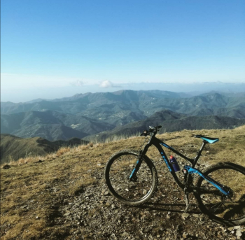
We descend a piece of dirt road and then take a left onto the ridge trail that will take us toward Rocca Cavallina, which is nothing more than a large rock. Before Rocca Cavallina you have to take a left to start descending on the south side, follow the path to Croci Pass, where you have to take the path in front of us that continues on the ridge.

You will thus arrive by the Chapel of San Rocco, follow the dirt road to the left, at the hairpin bend continue to the left and still following the trail you will find yourself on the road that leads back to the Scoglina Pass, after taking the asphalt road uphill to the left and covering the last few meters of elevation gain you will find yourself back where you started, at the Scoglina Pass.

Download our free mobile app to send this route to your Garmin device or to navigate it on OSM maps. Android - iOS
Local weather
Today
10 °C
Tonight
3 °C
Tomorrow
11 °C
Tomorrow night
8 °C
Sunday
12 °C
Sunday night
10 °C
Monday
13 °C
Monday night
12 °C
Tuesday
14 °C
Tuesday night
12 °C

Graph

Nearest Routes

2023/03/04
- Italy - Liguria, GE
Antosangui
(108)
41,57 km
Km
+1 577 mt
Vertical meters
Route difficulty
Landscapes
2023/02/28
- Italy - Liguria, GE
Antosangui
(108)
11,06 km
Km
+489 mt
Vertical meters
Route difficulty
Landscapes
2023/03/02
- Italy - Liguria, GE
Antosangui
(108)
23,14 km
Km
+712 mt
Vertical meters
Route difficulty
Landscapes
2023/03/06
- Italy - Liguria, GE
Antosangui
(108)
8,69 km
Km
+237 mt
Vertical meters
Route difficulty
Landscapes
2023/10/07
- Italy - Liguria, GE
ebsat
(107)
37,86 km
Km
+1 602 mt
Vertical meters
Route difficulty
Landscapes
2023/03/07
- Italy - Liguria, GE
BAROLO71
(34)
25,35 km
Km
+1 380 mt
Vertical meters
Route difficulty
Landscapes
2023/03/12
- Italy - Liguria, GE
ebsat
(107)
30,83 km
Km
+1 320 mt
Vertical meters
Route difficulty
Landscapes
2023/03/01
- Italy - Liguria, GE
Antosangui
(108)
20,22 km
Km
+740 mt
Vertical meters
Route difficulty
Landscapes
2024/04/22
- Italy - Liguria, GE
Antosangui
(108)
29,58 km
Km
+1 387 mt
Vertical meters
Route difficulty
Landscapes
2023/03/04
- Italy - Liguria, GE
Antosangui
(108)
29,39 km
Km
+1 379 mt
Vertical meters
Route difficulty
Landscapes

0 Comments