
 Italiano
 Deutsch
Crocetta Montallegro Anchetta

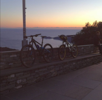
Depart from Pian dei Manzi in Fontanabuona. Follow the paved ascent to the Crocetta Pass, at the only fork stay on the main road and go to the right. Once you reach the Crocetta you will find a small chapel on the left, here the path leading to Montallegro starts. Just before arriving at the shrine you will find on the right two tracks of the path that lead toward the asphalt and allow you to lengthen the tour. Once in Montallegro, if you pass the portal on the right you will find yourself on the church square, as you can see it is worth going there to enjoy the view of Portofino.
To continue on the trail follow the paved road that takes you to the Casa del Pellegrino restaurant and then continue, the bottom changes and becomes natural but the trail remains wide and flowing, as long as you find the right line. You will then come to a fork, take a left and after a short climb the view of Zoagli will open up, but don't be distracted: the next piece of trail is slightly technical and a little exposed. After passing this section continue until you reach the colletta, where you will find a votive shrine, here descend to the left and thus arrive at the asphalt, cross it and continue on the path. Keep going downhill and you will enter another wider path, after a while you are on asphalt. Take a left and before you get to the village of Villa Oneto go down to the right always on asphalt, as soon as you find a parking lot on the right, take the dirt road on the left downhill, which will take you first to the calvari cross field and then into the valley. At the end of the asphalt road follow to the left and then following the signs for the slate bike path you will find yourself back in Pian dei Manzi.


