2023/02/26 17:38:22
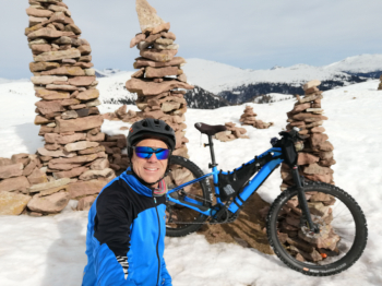
Ometti di pietra sulla neve da Merano
Author
Place
Italy - Trentino-Alto Adige/Südtirol, BZ
Km
48,20 km
Elapsed time
05:49:29
Vertical meters
+1 800 mt (288 - 2095)
Route difficulty
Landscapes
Last update
2023/12/04 13:46:51
Comments
Description
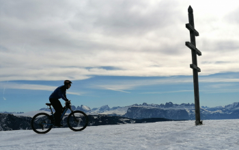
Fun and scenic route doable all year round, but even more beautiful if done with #snow and the right snow conditions. Very long and challenging from Merano, possibly you can start from Avelengo. From Avelengo it is doable both ways, with only minor differences.

From Avelengo you go up on snow-covered road to Leadner alm and then before the Verano hut you turn right on snow-covered forestry and reach the incredible little stone cairns at 2000 meters. From here you follow the European trail with a few pushing sections to the Merano hut.

Descend to Avelengo on snowy roads and trails and then on trail to Merano. Ideal for fat bike or ebike plus. On snow feasible only at least two weeks after the last snowfall, when the snow has settled.

Local weather
Heute

24 °C
Heute Abend

12 °C
Morgen

27 °C
Morgen Abend

17 °C
Montag

26 °C
Montagnacht

17 °C
Graph
Nearest Routes
2024/09/04
- Italy - Trentino-Alto Adige/Südtirol, BZ 64,42 km
Km
+1 900 mt
Vertical meters
Route difficulty
Landscapes
2023/03/01
- Italy - Trentino-Alto Adige/Südtirol, BZ 69,97 km
Km
+1 740 mt
Vertical meters
Route difficulty
Landscapes
2024/09/18
- Italy - Trentino-Alto Adige/Südtirol, BZ 56,20 km
Km
+2 300 mt
Vertical meters
Route difficulty
Landscapes
2023/03/04
- Italy - Trentino-Alto Adige/Südtirol, BZ 47,13 km
Km
+1 100 mt
Vertical meters
Route difficulty
Landscapes
2023/03/04
- Italy - Trentino-Alto Adige/Südtirol, BZ 96,84 km
Km
+2 220 mt
Vertical meters
Route difficulty
Landscapes
2024/07/25
- Italy - Trentino-Alto Adige/Südtirol, BZ 81,06 km
Km
+2 150 mt
Vertical meters
Route difficulty
Landscapes
44,14 km
Km
+2 100 mt
Vertical meters
Route difficulty
Landscapes
40,77 km
Km
+1 500 mt
Vertical meters
Route difficulty
Landscapes
36,69 km
Km
+1 310 mt
Vertical meters
Route difficulty
Landscapes
71,62 km
Km
+1 820 mt
Vertical meters
Route difficulty
Landscapes


 Italiano
 Deutsch

