
 Italiano
 Deutsch
2022/11/01 08:10:18
Sella Ronda pedalato orario
Author

Place
Italy - Trentino-Alto Adige/Südtirol, BZ
Km
51,53 km
Elapsed time
07:52:07
Vertical meters
+2 551 mt (1498 - 2291)
Route difficulty
Landscapes
Last update
2023/01/03 15:55:57
Comments
Hotels
Description
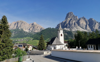
Beautiful route, fun and scenic, but also very long and very challenging, with technical descents.

It is 4 long climbs and 4 long descents (the classic 4-pass offroad tour), done clockwise with a few deviations from the official trail.
It can also be done of course by taking the lifts; I preferred to do it all pedaled, by ebike, and stopping before the last climb, at the White Wolf, to eat and recharge the battery.
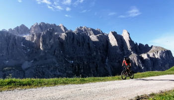
Some trail is perfectly smooth, like the ones coming down from gardena and sella, but others, like the Pordoi trail, is very technical and challenging, eventually there are easier alternatives.
Local weather
Thu 00:00

14 °C
Thu 12:00

20 °C
Fri 00:00
16 °C
Fri 12:00
19 °C
Sat 00:00
16 °C
Sat 12:00
20 °C


Graph
Nearest Routes
2024/06/01
- Italy - Trentino-Alto Adige/Südtirol, BZ 51,53 km
Km
+2 800 mt
Vertical meters
Route difficulty
Landscapes
43,35 km
Km
+2 300 mt
Vertical meters
Route difficulty
Landscapes
64,78 km
Km
+370 mt
Vertical meters
Route difficulty
Landscapes
33,18 km
Km
+1 910 mt
Vertical meters
Route difficulty
Landscapes
59,44 km
Km
+1 020 mt
Vertical meters
Route difficulty
Landscapes
58,55 km
Km
0 mt
Vertical meters
Route difficulty
Landscapes
28,18 km
Km
+1 467 mt
Vertical meters
Route difficulty
Landscapes
2024/09/18
- Italy - Trentino-Alto Adige/Südtirol, BZ 44,65 km
Km
+2 000 mt
Vertical meters
Route difficulty
Landscapes
44,97 km
Km
+1 590 mt
Vertical meters
Route difficulty
Landscapes