HOME RANKINGS CHALLENGES ROUTES NEAR ME PLANNING SEARCH LOGIN
Italy - Trentino-Alto Adige/Südtirol, BZ
2026/08/20 17:32:24

Da Merano a Sarentino

2 Downloads
0
 
Share

Key Takeaways / Scheda Tecnica

Disciplina:
Mountain Bike (MTB)
Percorso:
Da Merano a Sarentino
Località:
Italy - Trentino-Alto Adige/Südtirol, BZ
Distanza:
73,40 km
Dislivello Positivo:
+3 000 mt (Quota Min: 235m - Max: 1983m)
Difficoltà Tecnica:
2/5
Valutazione Panorami:
4/5
Formato Traccia:
GPX Download disponibile
Author
nonnocarb
(324)
Place
Italy - Trentino-Alto Adige/Südtirol, BZ
Km
73,40 km
Elapsed time
06:30:58
Vertical meters
+3 000 mt (235 - 1983)
Route difficulty
Landscapes
Last update
2026/08/20 17:50:50
Comments
0
Description

This route is very challenging due to the elevation gain, but it is not technically difficult; in fact, most of it follows forest roads or easy trails, so it can also be done on a #gravel bike. If you prefer, you can start from Avelengo to avoid the first climb on a paved road, which can be busy at certain times of day.
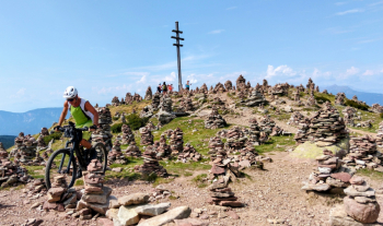
Foto itinerario MTB Da Merano a Sarentino - Italy - Trentino-Alto Adige/Südtirol, BZ

From Merano, climb to Avelengo, then continue uphill to the Merano mountain hut. You’ll reach the Ottenbacher alpine pasture and then descend to Sarentino (if you prefer, you can take the trails down).

Climb toward the Sarner Skihuette (refreshment stop) and then continue to the European trail. If you still have energy, you can climb up to the stunning stone cairns. Then descend to Avelengo and Merano via secondary roads or Trail 2.
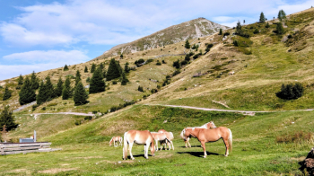
Foto itinerario MTB Da Merano a Sarentino - Italy - Trentino-Alto Adige/Südtirol, BZ

Download our free mobile app to send this route to your Garmin device or to navigate it on OSM maps. Android - iOS
Local weather
Tue 00:00
15 °C
Tue 12:00
17 °C
Wed 00:00
15 °C
Wed 12:00
14 °C
Thu 00:00
13 °C
Thu 12:00
15 °C
Fri 00:00
10 °C
Fri 12:00
12 °C
Sat 00:00
10 °C
Sat 12:00
13 °C

Graph

Nearest Routes

2023/03/07
- Italy - Trentino-Alto Adige/Südtirol, BZ
nonnocarb
(324)
33,38 km
Km
+1 600 mt
Vertical meters
Route difficulty
Landscapes
2025/11/10
- Italy - Trentino-Alto Adige/Südtirol, BZ
nonnocarb
(324)
65,30 km
Km
+1 800 mt
Vertical meters
Route difficulty
Landscapes
2025/04/29
- Italy - Trentino-Alto Adige/Südtirol, BZ
nonnocarb
(324)
65,11 km
Km
+1 800 mt
Vertical meters
Route difficulty
Landscapes
2023/03/05
- Italy - Trentino-Alto Adige/Südtirol, BZ
nonnocarb
(324)
93,54 km
Km
+2 520 mt
Vertical meters
Route difficulty
Landscapes
2024/05/13
- Italy - Trentino-Alto Adige/Südtirol, BZ
nonnocarb
(324)
94,24 km
Km
+2 400 mt
Vertical meters
Route difficulty
Landscapes
2022/10/28
- Italy - Trentino-Alto Adige/Südtirol, BZ
nonnocarb
(324)
52,87 km
Km
+1 754 mt
Vertical meters
Route difficulty
Landscapes
2023/03/01
- Italy - Trentino-Alto Adige/Südtirol, BZ
nonnocarb
(324)
61,03 km
Km
+2 156 mt
Vertical meters
Route difficulty
Landscapes
2024/12/01
- Italy - Trentino-Alto Adige/Südtirol, BZ
Staff
(110)
35,55 km
Km
+1 500 mt
Vertical meters
Route difficulty
Landscapes
2024/10/10
- Italy - Trentino-Alto Adige/Südtirol, BZ
Staff
(110)
29,33 km
Km
+1 650 mt
Vertical meters
Route difficulty
Landscapes
2023/03/01
- Italy - Trentino-Alto Adige/Südtirol, BZ
nonnocarb
(324)
76,06 km
Km
+2 300 mt
Vertical meters
Route difficulty
Landscapes

0 Comments
