HOME RANKINGS CHALLENGES ROUTES POI PLANNING SEARCH LOGIN
Italy - Trentino-Alto Adige/Südtirol, BZ
2023/03/05 10:17:56

Forcella di Soy da Merano

3 Downloads
0
 
Author
nonnocarb
(266)
Place
Italy - Trentino-Alto Adige/Südtirol, BZ
Km
93,54 km
Elapsed time
10:59:08
Vertical meters
+2 520 mt (285 - 2885)
Route difficulty
Landscapes
Last update
2023/03/06 08:00:22
Comments
0
Description

Very long and very tiring itinerary, but to reduce it just start from Lake Zoccolo in Val d'Ultimo instead of Merano, going up and down the Val d'Ultimo farm trail to Santa Geltrude. On the other hand, the landscape is gorgeous and wild and the trails are very beautiful.

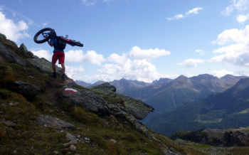
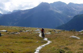
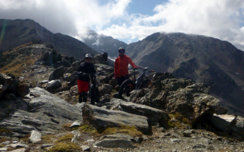
From Merano one arrives at Santa Geltrude. From here we climb up to the Untere Flatschbergalm (refreshment stop) and then pedal a little more to the beginning of the trail, Alta via Ultimo, which falsely takes us up to the start of the ascent with bikes on our backs. We now have 750 meters of elevation gain with only a few pedaled parts, up to the Soy Pass, in beautiful wild surroundings, with views of the Val Martello glaciers.

As a variant, there is the option of continuing on a challenging trail through the Martello valley and then returning via the Venosta valley. We, on the other hand, return through the Val d'Ultimo, on nice, even challenging trail to Santa Geltrude, then asphalt to Merano. To shorten the tour, just start from Santa Geltrude.

Download our free mobile app to send this route to your Garmin device or to navigate it on OSM maps. Android - iOS

Graph

Nearest Routes

2023/03/07
- Italy - Trentino-Alto Adige/Südtirol, BZ
nonnocarb
(266)
33,38 km
Km
+1 600 mt
Vertical meters
Route difficulty
Landscapes
2023/03/01
- Italy - Trentino-Alto Adige/Südtirol, BZ
nonnocarb
(266)
76,06 km
Km
+2 300 mt
Vertical meters
Route difficulty
Landscapes
2023/03/07
- Italy - Trentino-Alto Adige/Südtirol, BZ
nonnocarb
(266)
48,57 km
Km
+1 550 mt
Vertical meters
Route difficulty
Landscapes
2022/11/21
- Italy - Trentino-Alto Adige/Südtirol, BZ
nonnocarb
(266)
41,95 km
Km
+1 783 mt
Vertical meters
Route difficulty
Landscapes
2022/10/22
- Italy - Trentino-Alto Adige/Südtirol, BZ
nonnocarb
(266)
65,78 km
Km
+2 336 mt
Vertical meters
Route difficulty
Landscapes
2023/03/02
- Italy - Trentino-Alto Adige/Südtirol, BZ
nonnocarb
(266)
105,14 km
Km
+3 200 mt
Vertical meters
Route difficulty
Landscapes
2023/03/02
- Italy - Trentino-Alto Adige/Südtirol, BZ
nonnocarb
(266)
51,00 km
Km
+1 610 mt
Vertical meters
Route difficulty
Landscapes
2023/03/01
- Italy - Trentino-Alto Adige/Südtirol, BZ
nonnocarb
(266)
53,70 km
Km
+1 570 mt
Vertical meters
Route difficulty
Landscapes
2023/03/01
- Italy - Trentino-Alto Adige/Südtirol, BZ
nonnocarb
(266)
61,03 km
Km
+2 156 mt
Vertical meters
Route difficulty
Landscapes
2022/08/22
- Italy - Trentino-Alto Adige/Südtirol, BZ
nonnocarb
(266)
61,08 km
Km
+2 334 mt
Vertical meters
Route difficulty
Landscapes

0 Comments