Italiano
 Deutsch
Giro ad anello Livigno - Passo Forcola - Poschiavo - Ospizio Bernina (con 🚞) - Lagalb - Livigno

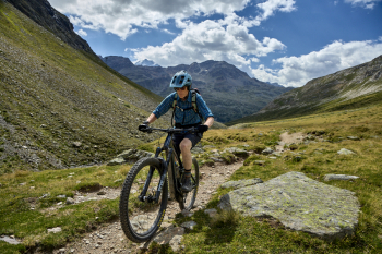
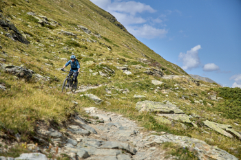
As the name suggests, this route runs mainly in Swiss territory. The departure from Livigno is up to if you want to add some positive elevation gain to the tour (which we preferred to do as well, since the initial idea was to start directly from the Forcola pass), being that from Poschiavo to go to Ospizio Bernina you make use of the little red train. I had never done Val Minor, I knew that it is usually done downhill, but I wanted to try it anyway from the Lagalb cable car station because from the map the hardest part I had already factored in was the final one, from the two small lakes to be clear. Unfortunately, I encountered a very bumpy trail for most of the ascent, so with a muscle bike, as I had, you have to have good legs, but in some places it is just hard to pedal, while with an electric like the one who was accompanying me it is more rideable although in some places you still need to get off so as not to do some damage to the bike.
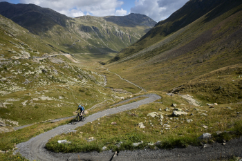
Our ride started from parking lot 8 in Livigno (the last one available going towards the Forcola pass, the first one if you are coming from the latter). We ride along a driveway in the middle of the valley, which gives its name to the pass, under the asphalt road with very rideable gradients until the last small bridge just below the pass where a series of hairpin bends with more important gradients unfold, but being "just started" tackled with some final breathlessness recoverable quickly. We continue by taking the paved road crossing the pass toward Switzerland and descend to the bridge where before crossing it, on the left, begins the long path that will take us to Poschiavo.
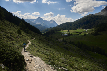
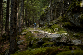
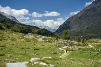
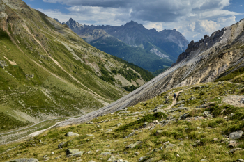
From here you can practically forget about the asphalt all the way to the bottom of the valley because a series of single tracks, driveways and historic paths alternate to give you more than 10km of descent. The first part, in fact, until it crosses the Camp Valley, is the one I was most curious about because it was only glimpsed from the road and maps but never traveled, and I can say it was a really nice discovery. It is not only downhill, there is some short ascent or plateau but always far from the noise of cars, surrounded by pine forests, fields kept in the English style (even at one point we found a small banquet with the possibility to refresh ourselves with food or drinks by leaving a small offering, obviously in Swiss francs) and breathtaking landscapes. At a certain point one finds oneself at a fork in the road and has to take the path on the right that follows the "historical trail" n.436 that comes out on a driveway that passes by some huts after which one has to take a path on the left that leads to a traverse that makes us pop up directly on the Camp Valley road (the one to Lake Saoseo to be clear). Here you always follow trail No. 436 and descend through a forest with a root-paved path followed by a small man-made section that leads to a bridge. Just past the latter keep the path to the right until you reach a driveway. Here you would have to climb a few meters to continue, but we unfortunately found a sign informing us that the path was unusable due to boulders falling on it and work in progress. There was a suggested detour that would require a hundred meters of elevation gain uphill and then a descent on a trail that TrailForks indicates as Black, so we preferred to descend and take the asphalt to resume after a couple of kilometers the historic trail that is on the right where the guardrail opens. This trail like the higher part is dotted with stones that will test your suspension of both bike and body.
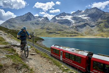
When the trail ends (you can tell because you pass a caution sign with children playing) you can decide to do asphalt all the way to the Poschiavo train station or do an in-and-out between the houses and meadows (we preferred the latter option). Tip: download the red train timetables from the website for the season you would like to do this tour and look carefully at which ones load bikes because there are some that are exclusively for pedestrians. At the station remember to say that you are carrying the bike and what your drop-off station is (for us it was Ospizio Bernina), ticket prices change depending on the route you take, while the cost of the bike is fixed.
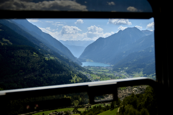
As you board the train, you can enjoy a well-deserved rest for your legs and arms as you admire the views that change as you ascend on the little train. Arriving at the Bernina Hospice we descend and toward the Lagalb cable car station first walking along the path that runs alongside the train tracks (if you are lucky you can even take a picture with it going up) with some up and down, then you pass the dam at the end of the lake to get away from the paved road and after a few hundred meters on a driveway you take on some single track where the riding skills come into their own in order to enjoy them to the fullest. Here you can see the skills of sliding the bike, pumping it out of corners without losing speed because the trail does not have great gradient. A delight!!!
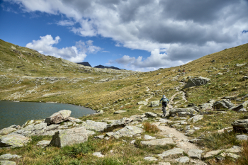
You still end up on a section of roadway after passing under the tracks and skirting to the left, then you head to the cable car to start the climb up Val Minor. You start with a nice tear and then the gradients are more rideable until you get, as I explained at the beginning, to the point where the boulders get bigger and more uneven. You push, you climb back in the saddle, you push, you climb back in the saddle for a while , until you meet the first lake. From here the sections in the saddle for the bikes become very limited but pushing is no problem, while on the second lake the trail is narrower and you have to be careful not to accidentally fall into the water.
Having finally reached Furcla Minor after about 100 meters of elevation gain mostly by pushing (for those with an electric less so) one can breathe a sigh of relief and enjoy the last stretch that takes us back to Passo Forcola on the now well-known trail No. 1 at the end of which one can have something to drink at the pass bar before tucking into the trail made at the beginning uphill through the valley to end the tour.
Final consideration:
- If you are patient rider people who know how to take a bike ride as a way to be outdoors in nature and beautiful scenery without paying attention to what the trails are like, the obstacle of going uphill in Val Minor is not a problem and you can enjoy a nice ride. If, on the other hand, you do not like to "ravine" then this ride might leave you a little bitter in the mouth.
- There would be the alternative of not doing the Val Minor (4.5km with 310 meters of elevation gain), but the Val da Fain (8km with 400 meters of elevation gain) then descending directly into Valle della Forcola from a decidedly steeper and more technical trail that is not for everyone and that forces you to start from Livigno (it depends on your riding level); I have never done it, maybe next time.
- You can also think about this ride starting from the Forcola pass without doing the Val Forcola up and down if you are not in Livigno or coming from Bormio, or starting and returning to Poschiavo by taking the little red train right away.
- I am tempted to do it again in the fall because I know the valley and its colors.