
 Italiano
 Deutsch
Livigno, Alpisella, Trela e Lago Nero

Lago Nero is a hidden gem of Livigno that wants to be conquered with sweat and burning hocks.
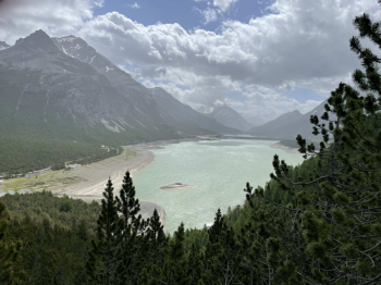
It starts in Livigno, skirting the lake of the same name to embark on the first steep climb of the day, the one that leads to the Alpisella Pass. Those who conquer it without an engine know what I'm talking about. 500 meters that pass quickly, in the sense that you climb fast because of the slope, but also slow, because your heart beats wildly and you yearn for the descent.
Descent that at first is on dirt road, then on trail (left orographic side) and passes the Adda springs before arriving at the Cancano lakes. It is easy and fast, the only pitfall being gravel in certain bends. Be careful of pedestrians. The panorama that opens before our eyes is fantastic.
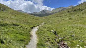
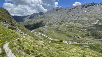
We enjoy a few kilometers of flat terrain along the lake before embarking on the steep climb to towards the Trela hut. There is a fountain before the actual climb. The next is at the malga. The gradients become hostile again, the views, however, are worth it as we then pass through a spectacular gorge. We thus arrive at the plateau of Malga Trela, pass "into" it and pull straight ahead. The trail is initially rideable, since the Valtellina Bike Marathon also passes there.
When we reach a fork, we turn right. From here we push the bike for about 30 minutes, with a short pedalable interlude. I do not recommend doing this section with pachyderm ebikes, because the trail gets very steep with steps that are not the best with those bikes. Today I saw 3 ebikers turn heel and retrace their steps. Better to continue to Alpisella Pass from the alpine hut of the same name following this trail. The lake is at the top of those shaded rocks:
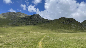
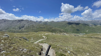
After finishing the push section, we are at 2500 meters altitude and the scenery is heavenly.
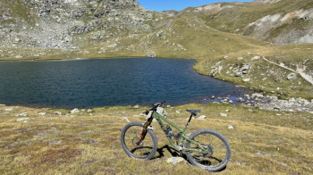
You see many different bikes in the photos because I go there every year. On the right you also see the trail that continues uphill, bikeable, to the highest point of the ride at an elevation of 2,600 meters. When you get to the top you see both Mottolino and the libidinous trail ahead. Be sure not to skid. It is an alpine trail, take your time enjoying it without ruining it. It is partly technical because of narrow passages and some rocky switchbacks, but in general it is a doable treat with good technique.
Past the steepest section we glide towards the Foscagno Pass. Watch out for some narrow and exposed passages, if you touch your handlebars with a rock you will fly down.
From the pass we take the path down the right side of the road, very fast if you have the wind in your favor. You pass some meadows with cows, so expect to shit yourself cheerfully, and you end up exactly at a very cool fountain, after several miles of trail. From here the trail continues up and down until it crosses the trail coming down from Trela Pass. We take it to the left and continue toward Livigno. There are no end of poisonous ramps, after a bridge there is one with 2 hairpin bends to go uphill and then a few more up and down before descending to Livigno Lake.
The trail leads to the Mottolino bike wash, and passes the Livigno Dairy if you want to get an ice cream.
-Tour not suitable for Ebikes-.


