
 Italiano
 Deutsch
Punta di Rims

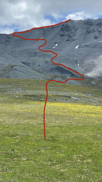
Forget Piz Umbrail and its hour-long backpacking bike ride. Ninety meters below (2946 meters) is Rims Peak and it is reached almost entirely by pedaling. What little you have to do down from the saddle is a simple push section. But let's start at the beginning.
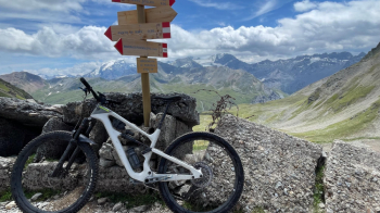
You start in Livigno and test your leg for the day's efforts with the steep climb from Alpisella. Since you'll have to leave early, you won't find merenderos with rented ebikes so you can see if your legs are spinning to tackle the day's 2,500 meters of elevation gain. So we enjoy the descent to the Cancano lakes, passing by the headwaters of the Adda River.
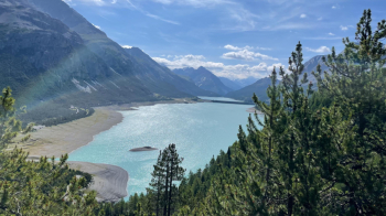
We skirt both lakes until just before the Fraele towers, where we abandon the day's hikers, pass over the dam and climb up a valley where no one is around. I highly recommend filling your water bottles in one of the streams to your left, because there will be none until below the Forcola (stream there, too). Don't worry, you won't get diarrhea.
What will seem impossible to you is instead doable without a problem: change sides and climb up an almost vertical wall on a military road recently put in place at its lower end.
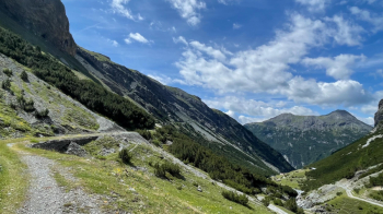
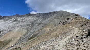
Further up it becomes trail again, but there is nothing to force you down from the saddle. Be forewarned, however: it is 900 meters of elevation gain on trail, perhaps the most beautiful climb in the Alps and so far a treat that few do in this direction. In fact, you will be met by Germans who, having started from the Umbrail Pass, do it downhill, which is rather boring (views aside) precisely because it can be done uphill.
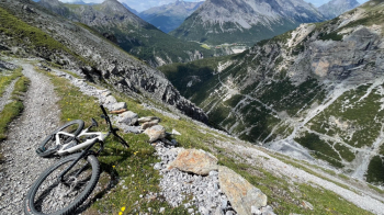
In the photo above on the lower right you see the road we took previously. Crazy to climb up here while pedaling! Further up we reach Alpe Pedenolo, and the green begins, leaving the steep slopes behind (for now).
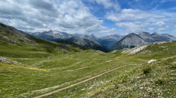
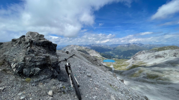
The air gets finer and finer, and you can feel it in your lungs and legs. We thus reach the Forcola pass, from where we see the Stelvio pass and the path from Umbrail to here. The barbed wire in the photo was from a World War I military post, of which the area abounds.
We ignore it and continue uphill to an old barracks from where we see the last fateful meters that will take us to the summit, somewhat pedaling, then pushing. If you are dying of thirst, to the right of the barracks you can see some kind of spring that used to fill the now demolished water tanks. The trail takes a detour to see the trenches; if you want the easier, more pedalable option, continue directly behind the barracks.
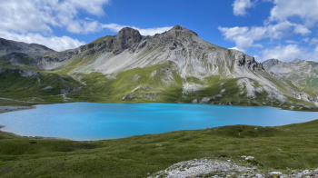
If you have been on Piz Umbrail before, you know how many people are there at the top. Here I was completely alone today, with a fabulous view, sheltered from the wind while eating a rye sandwich with cheese. Near the summit are the remains of military fortifications, they had even put a cannon there that reached Trafoi (Venosta Valley). Signs tell the history of these places during World War I. That turquoise spot is Rims Lake, our destination to keep in mind since we will get there with no trail or almost no trail.
In fact, we will descend initially to the ridge on the trail that leads right to Piz Umbrail (unfeasible with a bike) and then jump in to the left on a steep traverse where we will have to walk part of the way. Don't worry, we are on a scree, if we slide we won't make it to the valley.
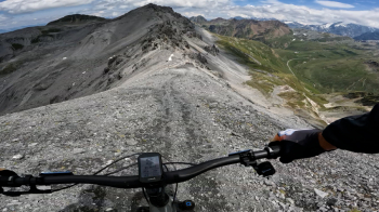
Once the traverse is over, the time has come to drop the bike and take the line we like best in the scree. Only caution: when you are on the meadows keep to the right to join the path coming from Piz Umbrail.
A stop at the lake is worthwhile, it is full of edelweiss near the banks and if you are daring you can even take a bath naked.
After that we descend to Val Mora on an initially technical and partly exposed trail, a real libido. Knowing how to nosepress helps. As we descend the exposure decreases and we enter a beautiful forest, where we eventually cross the Val Mora dirt road that we will take to the left uphill. It is about 300 meters of elevation gain to reach the top of this cool fountain.
From here it is several kilometers slightly downhill. The setting is fantastic, partly because no one is around in the afternoon. At one point we take a left turn toward Cancano, first on a cart track, then on a nice riverside trail that takes us back to Italy. In fact from Punta Rims onward we were in Switzerland. We thus change sides of the watershed, from the one carrying the waters into the Danube to the one carrying them into the Po, and arrive at the lakes of Cancano.
That's not the end of it: the steep ascent to Alpe Trela awaits us and the following one on trail to Trela Pass. On the plus side, by this time the merenderos with rented ebikes have already gone home, so we enjoy the racy descent to Livigno Lake. Don't forget the utimo strappetto that takes you over the river.
Back in Livigno you can splurge on beer and food, as you will have burned more calories than you can swallow in one evening. Of course it can be done by starting and arriving at the Cancano lakes. Right by the first dam there are plenty of parking lots. This way you take 1000 meters of elevation gain off the ride.


