2025/06/20 09:18:58
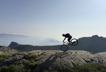
Sillara+Colle Monte Acuto
Author
Place
Italy - Emilia-Romagna, PR
Km
31,54 km
Elapsed time
09:50:20
Vertical meters
+1 699 mt (1117 - 1843)
Route difficulty
Landscapes
Last update
2025/06/26 10:17:11
Comments
Description
From Pratospilla we start towards Mount Sillara going up the now former ski slopes, we start immediately with a good elevation gain with pedalable stretches and shoulder bike sections. When you reach the end of the ski lifts you load your bike on your shoulders and head for Passo del Cavallo, then aim for Mount Lausanne and finally Sillara. When you get to the top you go down a fairly technical but doable single track in the saddle. Then you ride towards Foce Banciola and then descend from the Carbonaie towards Lagastrello, here the difficulty increases. Arrived at Lagastrello you point the refuge and then reach the Sella del Monte Acuto, then very nice descent.


Local weather

°C

°C

°C

°C

°C

°C
Graph
Nearest Routes
35,11 km
Km
+1 800 mt
Vertical meters
Route difficulty
Landscapes
33,33 km
Km
+2 171 mt
Vertical meters
Route difficulty
Landscapes
25,07 km
Km
+1 400 mt
Vertical meters
Route difficulty
Landscapes
38,25 km
Km
+1 950 mt
Vertical meters
Route difficulty
Landscapes
27,73 km
Km
+1 694 mt
Vertical meters
Route difficulty
Landscapes
40,87 km
Km
+1 699 mt
Vertical meters
Route difficulty
Landscapes
24,07 km
Km
+1 190 mt
Vertical meters
Route difficulty
Landscapes
24,52 km
Km
+1 634 mt
Vertical meters
Route difficulty
Landscapes
35,22 km
Km
+1 550 mt
Vertical meters
Route difficulty
Landscapes
176,89 km
Km
+6 700 mt
Vertical meters
Route difficulty
Landscapes


 Italiano
 Deutsch