
 Italiano
 Deutsch
Alpe del Corno

A short itinerary that allows you to admire the views of the Muggio Valley and ride one of the most technical descents in the area: the Alpe del Corno trail (difficulty S2 up to the alpine pasture of the same name, then S3).
Given the difficulty, please note that the descent requires adequate technical skills and is therefore not recommended for everyone! In any case, there is also a variant with a technically easier descent, which still allows you to complete the loop.
The route starts from Cabbio (convenient free parking on the left when arriving from the valley floor) and takes the road to the Bonello Pass. At the beginning, there are some steep asphalt ramps (12-14% gradient), then the road becomes unpaved and, after crossing the ford and passing to the opposite side, the gradient becomes gentler (5-6%) until you reach first the alp and then the Bonello Pass. From here, take a long traverse that leads to a fork with a bench near the Arla hill: as you climb, beautiful views of Mount Generoso, Mount Bisbino, Sasso Gordona, and Mount Rosa gradually open up.
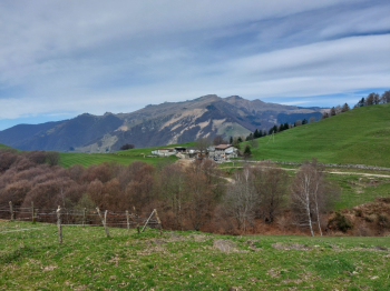
Alpe Bonello and the summit of Monte Generoso
Alternative route for those who prefer a less technical descent: from the bench, follow the signs for Cabbio, descending along the Dosso d'Arla trail (difficulty S1 with some S2 passages), which is not marked on the map.
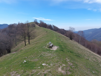
Dosso d'Arla (start of the alternative route with an easier descent)
The route continues by turning left along an undulating stretch along the hillside, which is easy at first but then becomes more challenging, even on rock, until you reach the Prabello refuge after crossing into Italy. Here you can enjoy a beautiful view of the Val d'Intelvi and the surrounding Prealps.
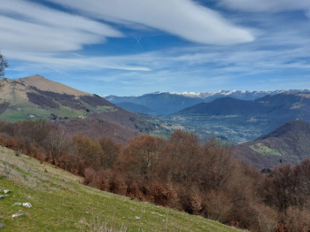
View from the Prabello refuge: Pizzo della Croce and Val d'Intelvi
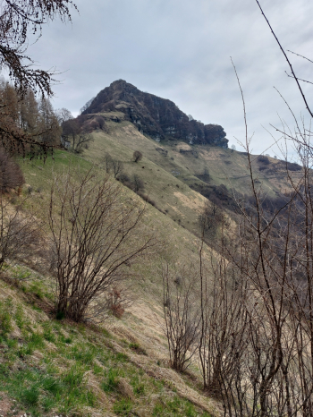
Sasso Gordona (the traverse to be followed is visible on the hillside)
Leaving the refuge, you follow a traverse that passes under the slopes of the rocky Sasso Gordona. This up-and-down section is exposed (steep meadows below, nothing extreme) and has some challenging passages. You will soon reach a ridge from which the descent to Alpe del Corno begins: at the start, the trail is fairly smooth and not particularly difficult, but after passing the border fence that marks the return to Swiss territory, it becomes more technical. You pass the farmhouses of the alpine pasture of the same name and reach the final part, which is steep, with many hairpin bends, often carved into the rock, and with various technical passages, all of which are short and easily overcome by dismounting from your mountain bike if necessary. Shortly before reaching a fork with yellow poles, take a link on the right that leads directly to the path to Uggine, avoiding the relaunch. Follow a short stretch along the hillside to a ford over a stream. From here, a short stretch with your bike on your shoulder leads first to a dirt road and then, after passing the small village of Uggine, to a paved road that leads back to Cabbio.
Alternatively, at the fork with the yellow posts, you can continue left towards the valley floor until you reach the bridge over the Breggia stream. From here, you return to Bruzella along the Crotta valley.
Route traveled on 10.04.2025 by mountain bike.


