HOME RANKINGS CHALLENGES ROUTES POI PLANNING SEARCH LOGIN
Italy - Emilia-Romagna, PC
2024/07/21 21:14:28

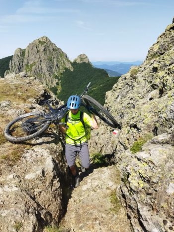
Monte Trevine e Secret Trail

0 Downloads
0
 
Share
Author
Antosangui
(107)
Place
Italy - Emilia-Romagna, PC
Km
21,21 km
Elapsed time
03:47:14
Vertical meters
+865 mt (1102 - 1657)
Route difficulty
Landscapes
Last update
2024/07/22 08:33:40
Comments
0
Description

This route starts at the Penna Barracks, climbs on asphalt to Chiodo Pass where you leave the bitumen to find it again at the end of the loop. From Chiodo Pass you take a right onto singletrack that passes over the road you have just traveled, then turn left and stay at altitude with a nice eat and drink until you reach the junction to the Nave, where you take a left. Here begins a bit of backcountry biking, with a few bits of pedaling. At the fork below the Pennine you take a left and shortly reach the Trevine, with one last tricky shouldered piece, but for the view of the Penna it is worth it.

From here begins a nice descent to Rifugio Faggio dei 3 comuni, all in the woods. Twenty meters before reaching the refuge we take a right on a path through the woods that leads us to the dirt road, where we take a right. Past the Taro springs we take a left onto the Secret trail, it is marked with a yellow arrow. This trail leads us to the Santa Maria dam, where we take a left onto dirt road. After taking a left on dirt uphill we come to a very fresh spring, we continue uphill and pass again at the source of the Taro, this time we ignore the yellow arrows and continue uphill to the Incisa pass, where we descend on dirt to the sawmill where we take a left on dirt to Cereghetto. After a few km we take under road on the right singletrack that takes us back to the Penna Casermette where the tour ends.

Download our free mobile app to send this route to your Garmin device or to navigate it on OSM maps. Android - iOS
Local weather
Oggi
15 °C
Stasera
11 °C
Domani
17 °C
Domani sera
10 °C
martedì
17 °C
Martedì notte
9 °C
mercoledì
16 °C
Mercoledì notte
9 °C
giovedì
11 °C
Giovedì notte
3 °C

Graph

Nearest Routes

2023/03/04
- Italy - Liguria, GE
Antosangui
(107)
12,81 km
Km
+298 mt
Vertical meters
Route difficulty
Landscapes
2023/03/07
- Italy - Liguria, GE
Antosangui
(107)
13,73 km
Km
+502 mt
Vertical meters
Route difficulty
Landscapes
29,52 km
Km
+1 186 mt
Vertical meters
Route difficulty
Landscapes
2023/04/30
- Italy - Liguria, GE
miciolo
(39)
33,40 km
Km
+1 317 mt
Vertical meters
Route difficulty
Landscapes
2022/11/24
- Italy - Liguria, GE
P.Fizz
(5)
29,07 km
Km
+1 202 mt
Vertical meters
Route difficulty
Landscapes
2022/11/22
- Italy - Emilia-Romagna, PR
P.Fizz
(5)
21,79 km
Km
+978 mt
Vertical meters
Route difficulty
Landscapes
2022/11/23
- Italy - Emilia-Romagna, PR
P.Fizz
(5)
31,63 km
Km
+1 250 mt
Vertical meters
Route difficulty
Landscapes
2023/02/28
- Italy - Liguria, GE
Antosangui
(107)
39,07 km
Km
+750 mt
Vertical meters
Route difficulty
Landscapes
2023/02/24
- Italy - Liguria, GE
Antosangui
(107)
24,39 km
Km
+1 172 mt
Vertical meters
Route difficulty
Landscapes
2023/03/06
- Italy - Liguria, GE
Antosangui
(107)
7,02 km
Km
+392 mt
Vertical meters
Route difficulty
Landscapes

0 Comments