Italiano
 Deutsch
APPENNINO LIGURE: DAL PASSO DEI PORCILETTI AL MONTE AIONA

Super itinerary in the heart of the Ligurian Apennines on the border of the provinces of Genoa and Parma that offers splendid views on superlative trails. Notice that the itinerary is suitable for those who are willing to tackle sections on foot or with bikes on their backs. The stretches are short but the hike may prove unpleasant to those who just want to pedal.
To get an idea read carefully the photoreport found here.
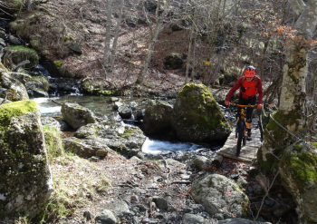
The start is from the Casermette del Penna Refuge, where on a comfortable dirt road you reach Passo Incisa. From Incisa Pass up to Porciletti Pass the trail is all in beech forest and there will be several short push bike sections. One could descend to the valley but on the net we found that at a pasture below Maremma dogs caused problems for hikers. To avoid them we stayed high along a very well-maintained trail that, however, stops near a gully and we consequently turned back a few hundred meters until we found a nice technical trail that descends a little. We manage on a small bridge to ford the creek and on the other side the bikes go up on the shoulders for a short stretch of shoulder biking.
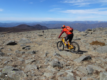
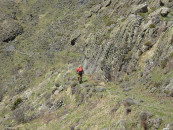
We go to intercept the Trail of the Carts, used in the past to bring wood down from the beech forests. This trail is a long traverse all on rock that is not difficult but slightly exposed with superlative views. The traverse ends on the dirt road that climbs from Prato sopra la Croce. Now quiet climb up to the Spingarda Pass passing the peculiar Pietra Borghesa. At Passo della Spingarda begins the hard climb to Monte Aiona (1701 meters), rideable almost all the way up if you have good legs. We then descend on the other side in a lunar environment with stones everywhere and join theAlta Via dei Monti Liguri.
We lose altitude until we intercept the traverse that, still on trail, takes us to another characteristic place. the north slope of Mount Aiona and its Cirighetto Pass.
This stretch is also not difficult but it is partly exposed and it is necessary to pay a modicum of attention. We descend on nice dirt road into the forest until we intercept the super flow trail: Green dot? (not sure about the color). We pass 500 meters from the cars and still on trails we go to the Nave area of Mount Penna from where the trail named Schettino starts. This trail is very narrow in places with twists and turns even on steep sections. The trail ends on the asphalt which we will ride for about 1km until we find a nice dirt road in the pine forest that with several up and downs takes us back to the cars.
Itinerary that passes through remote areas, so don't do it alone and especially don't do it unless you are sure to find more than excellent weather. On the summit flats of Mount Aiona the weather changes very quickly and in case of low clouds a well functioning gps is a must.
Credit for this trail is due to Paolino who scouted out the Trail of the Carts which is not marked on the maps.