
 Italiano
 Deutsch
Passo Ezendola Passo Baione

Mountaineering cycle ride with big exaggerated bike section, descent from Baione fantastic. Start from Lozio from an altitude of 1000 meters, we climb on a road with a challenging slope, we pedal also in mtb until 1500, from here the slope is not extreme but the bumpy bottom allows to pedal it only in Emtb.
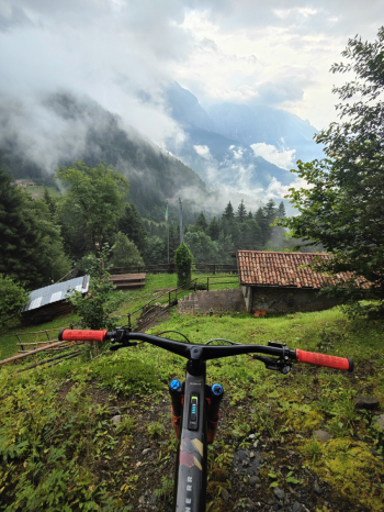
Arrived at the junction of the CAI 106 path we discover that there is no path so we continue on pratone straight for straight on ridge quite upright until 2000 meters altitude (in Emtb pushed, in mtb on shoulder), reached the path that goes up to the Ezendola peak we deviate to the relative pass. Protections on, we throw ourselves on the first descent, an S3 not extremely challenging but with mainly gravel bottom, so not too exciting either
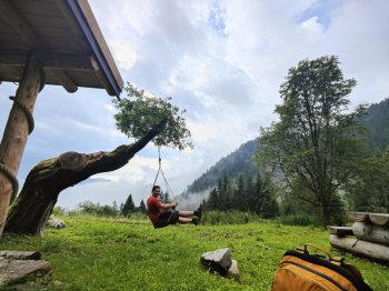
At an altitude of 1650 meters from the Ezendola spring the idea was to descend from the S4 trail towards Schilpario but we stop after the first 50 meters done by hand on a too vertical and slippery bottom at that time, so we fall back on the "long trail", it is an S1 trail without any technical difficulty with several up and down , we then deviate towards a trail on a similar style but faster and more fun that comes out at an altitude of 1350 on the road that goes up towards Verrobbio. We remove the protections and continue on the road to the junction at elevation 1550 meters where behind the restaurant on the left we refill water. On fairly compact concrete and gravel we continue fairly comfortably in the Bagozza valley to the Campelli pass.
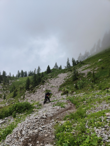
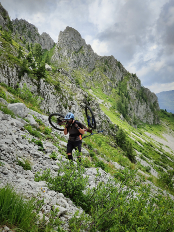
From here up to the Baione pass there are about 350-400 meters not rideable, it is a long very narrow path with often gravel bottom and many up and down, so push bike for a good kilometer, then bike on your back to climb the last 230 meters on a very vertical path where it is forbidden to fall back, there are also passages of I° and II° where you have to climb with your hands, the rotten rock does not help in the task and must be evaluated very carefully, in two we help ourselves by passing the bike and finally we arrive very tired at the pass.
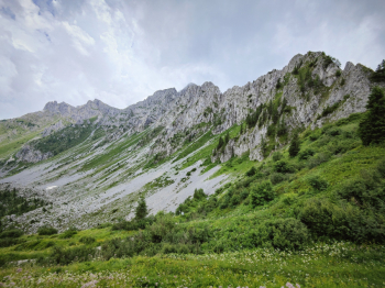
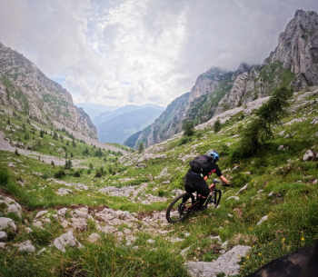
Here at the pass the view is fantastic, we are in an arena in the middle of several ridges such as Cima di Baione, Cima Mengol and Cima di Bacchetta. which will accompany us during the very long descent (1h30 for 1000 meters of elevation gain). The descent initially is on meadows with rocks that make it difficult to find the most comfortable line to stay in the saddle, soon after it starts to descend and the games get interesting, it is a S4 trail with many very technical passages, nice to try to close. It alternates between several sections of scree that are nevertheless fun. the further you go the more the difficulty reduces to a medium S3. Except for about 5 minutes there are no special exposures.
Arriving almost downstream at the little church we deviate to the left one last section S1 and one S2. Personally if I ever do this again instead of Ezendola Pass I would try to descend to Lifetto Pass on 420.
Trail style: AM
Personal rating: views 10/10; Baione bisque 10/10; Ezendola 7/10
Very challenging push and shoulder section
MTB: yes
EMTB: no
Duration about 9-10h
Shoulder section: 300 meters push +200 shoulder to Ezendola; 150 meters push +250 shoulder very vertical to Baione.
Difficulty ascent: Ezendola side very challenging, Schilpario north side comfortable
Difficulty descent: mainly S3/S4
Exposed: yes, shoulder section up to Baione, and a short downhill section from Baione.
Drainage: done after a day of extreme rain we found everything dry (except the "long trail")
Water points: Lozio; Bagozza refuge area, San Carlo spring at the end of the Baione descent


