HOME RANKINGS CHALLENGES ROUTES NEAR ME PLANNING SEARCH LOGIN
Italy - Emilia-Romagna, PC
2024/04/09 17:37:18

Monte Dego

5 Downloads
0
 
Share
Author
pozzoligio
(93)
Place
Italy - Emilia-Romagna, PC
Km
54,35 km
Elapsed time
06:32:02
Vertical meters
+2 450 mt (441 - 1449)
Route difficulty
Landscapes
Last update
2024/04/09 17:45:51
Comments
0
Description

Challenging clockwise ride, start from Bagnolo on asphalt to Santa Maria on small winding road then trail to ridge dirt road. Now tough climb to Mt. Burrows with ruined and steep sections, nice view from summit. Now narrow trail slightly downhill, then after pass 5 min push up narrow trail then pedal up and down to Mt. Veri pass. Short asphalt then long climb on dirt road to Mt. Dego church where there are nice views of Mt. Alfeo and Mt. Lesima.
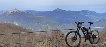
Now it becomes a trail: climb a little more then descend to the Foppiano refuge, those who are tired go right down the trail and connect to the loop further down. The trail continues as it becomes more challenging with steep climbs and descents and a few short sections on foot. Past the rocky Mount Gifarco you descend to the right towards Fontanigorda, disheveled start then becomes a nice path then road, follow the yellow markers. At the playground follow the little path marked by the yellow stickers, at the asphalt begin to climb, first asphalt then dirt road until the barrier.

Now left, the trail is about 20 meters to the left and climbs very steep even though it is short. Now long descent, rough start then becomes a nice trail, spectacular view from the rocks with somewhat challenging passages. At Foppiano you cross and climb briefly on little trail, then long and nice trail to asphalt, short climb then a few km downhill and back to the start. Low speed ride even on ebike.


Download our free mobile app to send this route to your Garmin device or to navigate it on OSM maps. Android - iOS
Local weather
°C
°C
°C
°C
°C
°C
°C
°C
°C
°C

Graph

Nearest Routes

2023/05/09
- Italy - Emilia-Romagna, PC
pozzoligio
(93)
58,24 km
Km
+2 274 mt
Vertical meters
Route difficulty
Landscapes
2023/10/12
- Italy - Emilia-Romagna, PC
pozzoligio
(93)
54,49 km
Km
+2 400 mt
Vertical meters
Route difficulty
Landscapes
2024/03/24
- Italy - Liguria, GE
tado79
(15)
46,67 km
Km
+2 200 mt
Vertical meters
Route difficulty
Landscapes
2023/03/22
- Italy - Emilia-Romagna, PC
pozzoligio
(93)
56,84 km
Km
+1 830 mt
Vertical meters
Route difficulty
Landscapes
2023/05/26
- Italy - Emilia-Romagna, PC
pozzoligio
(93)
63,02 km
Km
+2 061 mt
Vertical meters
Route difficulty
Landscapes
2024/05/27
- Italy - Emilia-Romagna, PC
miciolo
(40)
41,70 km
Km
+1 850 mt
Vertical meters
Route difficulty
Landscapes
2023/03/13
- Italy - Emilia-Romagna, PC
pozzoligio
(93)
66,61 km
Km
+2 450 mt
Vertical meters
Route difficulty
Landscapes
2023/11/28
- Italy - Emilia-Romagna, PC
miciolo
(40)
32,38 km
Km
+1 500 mt
Vertical meters
Route difficulty
Landscapes
2022/11/03
- Italy - Emilia-Romagna, PC
pozzoligio
(93)
35,50 km
Km
+1 427 mt
Vertical meters
Route difficulty
Landscapes
2023/04/23
- Italy - Emilia-Romagna, PC
pozzoligio
(93)
39,99 km
Km
+1 530 mt
Vertical meters
Route difficulty
Landscapes

0 Comments