HOME RANKINGS CHALLENGES ROUTES POI PLANNING SEARCH LOGIN
Italy - Lazio, RI
2024/01/31 17:51:18

Monte Terminillo

4 Downloads
0
 
Author
Place
Italy - Lazio, RI
Km
34,37 km
Elapsed time
10:19:12
Vertical meters
+1 948 mt (557 - 2192)
Route difficulty
Landscapes
Last update
2024/01/31 18:15:28
Comments
4
Description

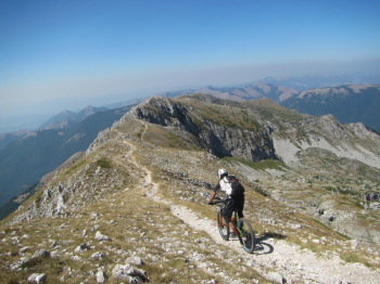
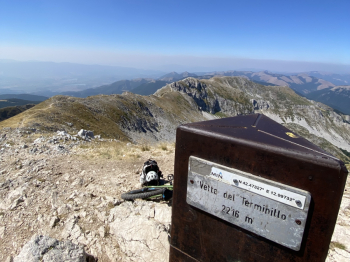
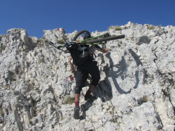
Terminillissimo. That's what we called this tour. Yes because climbing Terminillo starting from Rieti without ever touching asphalt and doing practically all the descent on trail is not easy at Terminillo. Ascent from the Lisciano valley, not steep but with a bumpy surface that put us to the test. Arrival at Pian de Valli and ascent to the summit via the Terminilletto with several first grade passages that force you to climb on all fours. Fantastic Sassetelli ridge also with a couple of heart-pounding passages. Very challenging first part of the descent from Cima di Vall'Organo to La fossa refuge. From here we climb back up to Pian de Valli to take trail 409 to Pian de Rosce to then continue on the historic Duce trail to which we add Macchiole DH that passes precisely in the abandoned village of Macchiole. After 10 hours 34km and almost 2000 meters of elevation gain we arrive down at the cars


Download our free mobile app to send this route to your Garmin device or to navigate it on OSM maps. Android - iOS

Graph

Nearest Routes

2024/02/29
- Italy - Abruzzo, AQ
39,84 km
Km
+1 610 mt
Vertical meters
Route difficulty
Landscapes
2023/06/26
- Italy - Umbria, PG
37,07 km
Km
+1 000 mt
Vertical meters
Route difficulty
Landscapes
2024/01/31
- Italy - Lazio, RI
25,87 km
Km
+1 656 mt
Vertical meters
Route difficulty
Landscapes
2024/04/15
- Italy - Umbria, PG
nirusteso
(3)
40,13 km
Km
+425 mt
Vertical meters
Route difficulty
Landscapes
31,22 km
Km
+900 mt
Vertical meters
Route difficulty
Landscapes
44,85 km
Km
+1 600 mt
Vertical meters
Route difficulty
Landscapes
2024/02/01
- Italy - Abruzzo, AV
24,69 km
Km
+1 722 mt
Vertical meters
Route difficulty
Landscapes
2023/10/31
- Italy - Marche, AP
@lessio
(2)
38,13 km
Km
+1 700 mt
Vertical meters
Route difficulty
Landscapes

4 Comments