Italiano
 Deutsch
Bocchetta di Chiaro - Vikingo Trail

Very scenic route at the top of Lake Como, with splendid views of the northern branch of the lake and the surrounding mountains including the famous Legnone, descent with a wooded bottom flowing at times, technical and steep but never extreme, I would say an average S2.
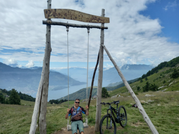
Departure from Sorico from one of the few free parking lots, rather comfortable and sun exposed ascent on asphalt until Fordeccia and the famous Baita del Vikingo, from there on it gets harder, then it becomes a forestry in the woods with very steep sections until you get to the wonderful Alpe di Mezzo, a basin full of huts and grazing animals. From here the last 100 meters of elevation gain by push or shoulder to Bocchetta di Chiaro, where there is the characteristic wooden swing, from which there is a fantastic view of Lake Como. If you wish, you can continue to the top of Mount Berlinghera for a total of about another 250 meters of elevation gain, again by pushing.
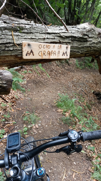
Back on your own steps to the Alpe you take the Vikingo descent, all enjoyable in the saddle but not to be underestimated, arrived back to Fordeccia you do a piece of asphalt downhill and then take the "Sensone" descent and then the Emotion Trail, here pay VERY ATTENTION when you arrive in a small valley marked with wooden danger signs, because you have to ford a small stream and if you go wrong direction you risk to fall from a waterfall.
After a slight ascent from the little valley the trail continues to Montemezzo, from here on it is actually a rather boring mule track but by now we are at the end of the loop. I would like to point out that I rode this tour in July 2023 and do not know the current conditions, I also disclaim any responsibility if the route is not rideable or appropriate for one's riding ability.