Italiano
 Deutsch
Lago dietro La Torre da Usseglio

Tour to be done on not too sunny days with a focus on the flocks and their dogs at Alpe Sulè.
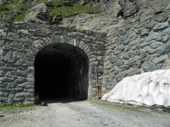
From Villaretto at an altitude of 1,260 meters, near the La Furnasa restaurant, take the asphalt road that immediately climbs steeply into the woods, passing the hamlet of Castello and Arnas. Continue uncovered always on asphalt passing Alpe Sulè (1660 meters) and Alpe Bessanetto and begins wide dirt road; you arrive at a tunnel, inside which there is a usually open gate that in case of a padlock is possible to pass with some acrobatics for the bike.
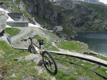
Exiting the tunnel, a few hairpin bends remain and you reach the buildings of the hydroelectric power plant, and then the small lake reservoir behind La Torre at 2,366 meters. As stated on the Usseglio Municipality website, this is an example of industrial archaeology: you can see the now abandoned buildings used by the workers and the arrival of the small narrow-gauge "Decauville" railway that, in the 1930s, bypassing the slopes of the Lera massif, connected Lake Behind the Tower to Mount Bassa (where the pipelines begin to plummet almost vertically toward Crot) and to the Malciaussia dam, also using some tunnels. The track where the railroad passed is visible halfway up the orographic right side of the valley.
The dirt road, very hard in places, continues to the left of the lake, entering the beautiful upper valley, furrowed by numerous streams, up to an elevation of about 2,500 meters. It is also possible to leave the bike and climb to Lake della Rossa via a good trail (30-45 minutes). Obligatory descent on the ascent route.