Italiano
 Deutsch
Uja of Ciamarella 3676 m

Authentic Cycloalpine itinerary with almost full Portage, glacier to cross, very technical and exposed descents to be tackled only with determination, preparation and caution.
In the obsessive search for new Peaks to raid in late August I get thunderstruck by some photos stolen from bagna caüda trekkers: Uja di Ciamarella, the highest Peak in the Lanzo Valleys. Will it be "cyclable" ? No info. After consuming all the XXX material available on the net, all that remains is to try it and go see. Perfect team: Andrea and Phoebe.
Start from Balme 1430 m Val d'Ala TO, to avoid 0% rideability in the stats but especially to avoid the 3 euro gabella at Piani della Mussa. Convenient parking and water. 400 m of elevation gain in 6 km can be enough. Taka zü ! From here to the top is practically full Portage with only a few resting push sections. Nice steep until Pian dei Morti 2050 m then more "easy" until the beginning of Pian del Gias 2500 m which has practically nothing left of Gias. The goal is always far above our heads and given the scree and scree you really have to believe it to scramble a bike around here :-) However, there are no equipped or difficult sections, just a few "easy rocks" and a lot of effort. At 3100 m we put on crampons and pass the poor glacier without problems. Obvious and avoidable crevasses. At 3300 m we take up the trail again, which rises vertically, traverses below the summit and with a few more delicate last meters comes out on the shoulder at 3530 m. That's it, last cent and the bust of St. Leonard Murialdo and the patron saint of the Ciclodisagiati welcome us on 3676 m. Marooo !
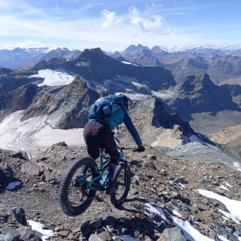
Total panorama of practically all the NW mountains from Monviso to the S to Bianco to the N. The nearby glaciers des Evettes, Tonini, Sea galvanize and give more of a sense of altitude since the nearby high mountains mitigate this feeling.
Descent ON: all of the shoulder since the summit is entirely bikeable, glacier-sloping, well navigable and tracked. Social photos on tape. Followed by a few meters of similar unclimbing and long traverse with two possible options. High as in the climb or slightly lower. We take the low one and go off precise with only a few feet on the ground in the first part. The next steep section is a blast with skilful S's and friendly almost sandy terrain up to the glacier where we don't even put crampons on anymore but staying more to the left than the ascent we remain unexpectedly in the saddle on excellent ice made grippy by the loam. Boja faüss ! The next section to pass the cliff supporting the glacier is discontinuous but still fun with nice passages on smooth rocks to interpret. No complaint. At 3050 m short appiedamento to get around the ridge keeping as reference obvious cairn. Follows nice challenging part, vertical with hairpin bends as narrow as butts and with little grip. As soon as the slope decreases you can relax but still with commitment and fun until about 2790 m. 50-100 m NC-NR for big, steep mouthfuls. More short flowing section follows until the small bridge where the bike goes back on the shoulders. Change mental set-up and aim for Rifugio Gastaldi 2659 with some up and down among wild combe (obvious fork at 2590 m). Descending near the old cable car we see the large Rifugio strategically placed just below the Bessanese(Rifugio gastaldi). Last bar and we are ready for the last 800 m of descent. We start brightly but soon the trail becomes still very technical and difficult. Lots of switchbacks and as many tracks and shortcuts but even the seemingly easier ones are actually quite wearing and challenging well stuffed with rocks and various obstacles. 1 hardware section of very few meters but no problems. Alè bon courage, we continue between hairpin bends and various rocks up to Gias Naressa 2200 m and beyond. Not enough, bar is raised further with increasingly bad and trialistic trail. I ask for the public's help. More cliffs, tight switchbacks and death rocks. Forearms and hands to throw. I make the call home. More pointed cliffs and crags. Shimano help me. Discomfort and Suffering ! Landed at Alpe Rocca we make out as per tradition cow dung still in disbelief that we have all our teeth in place. Maroo what a scarling !
After passing the plans we shawl back to the car on bucolic forestry and some ST. Very nice little finish on nice trail and Gorgia waterfall.
In conclusion: Uja di Ciamarella 3676 m the new Queen of Italy, the highest "cyclable" summit on trail in Italy.
Technical difficulty: Very Difficult+
Physical Condition: Very Hard+