HOME RANKINGS CHALLENGES ROUTES POI PLANNING SEARCH LOGIN
Italy - Emilia-Romagna, PC
2023/07/30 09:44:32

Magico Appennino Ligure

58 Downloads
4
 
Share
Author
miciolo
(40)
Place
Italy - Emilia-Romagna, PC
Km
30,14 km
Elapsed time
06:48:14
Vertical meters
+1 340 mt (1306 - 1783)
Route difficulty
Landscapes
Last update
2023/07/30 09:53:53
Comments
0
Description

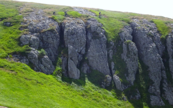
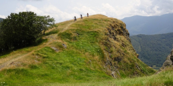
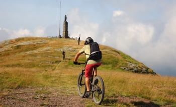
Here is the trail for one of the most beautiful rides in the highest peaks of the Ligurian Apennines between the provinces of Piacenza, Parma and Genoa. The percentage of asphalt is zero, only 250 linear meters, the rest is all trails winding from 1300 to 1800 meters. All in the name of flow. There are several pushing sections in the itinerary, amply rewarded by the views offered.

A few tips before embarking on this hike:

  • the weather must be perfect.
  • Some points are very exposed especially near the peaks.
  • It is also an area shared by other mountain users, so be careful and always give way especially if you have a motor.

The start is from the Zovallo Pass, which marks the border between the provinces of Piacenza and Parma. In order you will touch:

Black Lake

Costazza

Mount Maggiorasca

Mount Croce Martincano (short A/R)

Rocca del Prete (short A/R)

Onion Meadow

Frozen Fountain

Ciapa Liscia

Tribulated Valley

Red Groppo

Roncalla Mountain

More information at this link.
Download our free mobile app to send this route to your Garmin device or to navigate it on OSM maps. Android - iOS
Local weather
°C
°C
°C
°C
°C
°C
°C
°C
°C
°C

Graph

Nearest Routes

2023/03/06
- Italy - Emilia-Romagna, PC
Antosangui
(108)
16,04 km
Km
+473 mt
Vertical meters
Route difficulty
Landscapes
2022/11/04
- Italy - Emilia-Romagna, PC
pozzoligio
(93)
59,32 km
Km
+1 994 mt
Vertical meters
Route difficulty
Landscapes
2024/02/05
- Italy - Emilia-Romagna, PC
pozzoligio
(93)
46,12 km
Km
+1 700 mt
Vertical meters
Route difficulty
Landscapes
2023/02/28
- Italy - Liguria, GE
Antosangui
(108)
39,07 km
Km
+750 mt
Vertical meters
Route difficulty
Landscapes
2023/03/07
- Italy - Emilia-Romagna, PC
Antosangui
(108)
8,87 km
Km
+479 mt
Vertical meters
Route difficulty
Landscapes
2023/02/24
- Italy - Liguria, GE
Antosangui
(108)
24,39 km
Km
+1 172 mt
Vertical meters
Route difficulty
Landscapes
2022/11/07
- Italy - Emilia-Romagna, PC
pozzoligio
(93)
58,83 km
Km
+2 161 mt
Vertical meters
Route difficulty
Landscapes
2023/04/01
- Italy - Emilia-Romagna, PC
pozzoligio
(93)
49,83 km
Km
+2 100 mt
Vertical meters
Route difficulty
Landscapes
2023/03/06
- Italy - Liguria, GE
Antosangui
(108)
7,02 km
Km
+392 mt
Vertical meters
Route difficulty
Landscapes
2023/10/23
- Italy - Emilia-Romagna, PC
miciolo
(40)
31,87 km
Km
+1 130 mt
Vertical meters
Route difficulty
Landscapes

0 Comments