
 Italiano
 Deutsch
Rocca d'Aveto Borzonasca

Itinerary connecting Santo Stegano d'Aveto with Borzonasca.
Departing from the square of the chairlift in Rocca d'Aveto, take the dirt road on the right uphill right in front of the lift, after passing two challenging ramps turn right onto the cross-country trail following for Passo della Lepre. In the fall season the layer of leaves on the ground and the bare trees add a special touch.
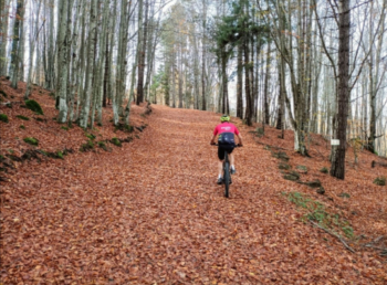
At the end of the dirt road you cross the asphalt and cross it to continue on the cross-country track. This brings you to the asphalt road that leads to Chiodo Pass, the dirt road flanks it and allows you to avoid some parts. This brings you to the Chiodo pass where you take a right downhill and after a short while you reach the Penna barracks. You leave the asphalt and take the dirt road to the left, after a few hundred meters on the right is a sawmill, here you follow the dirt road to the right downhill. Occasionally among the trees there is some opening and the view is worth it. Dad's E-bike that wanted to capture the return on the bike, I had no other photos :)
So So arrives at the Cerighetto/Re di Coppe refuge, where you continue straight uphill until you reach the Cerighetto pass, from where the A2 trail begins and you follow it to the end. Watch out for the piece that crosses the landslide on the north side of the Aiona; it is rideable but still exposed. You always follow the main path, except that at the moment when the trail widens, after a few tens of meters you have to take the path to the left and leave the dirt road. At the end of the trail you find yourself at Mogetto Lake, take the dirt road to the right and after a few hundred meters leave it for a nice flow trail on the left. At the dirt road we take a left and immediately left again, with an easy single track we return to the dirt road where we go right. This brings us to the Lame pass where there is a hut unfortunately closed but still there is a possibility to refill water from the outside sinks. At the pass we take the dirt road to the left, after a piece of false level you will see arrows on the right indicating the recently opened path leading to Lake Giacopiane. The first part requires some navigation because there are some logging trails that cut the trail, after that just follow the arrows and you will find yourself by the lake dam. You walk along the dam and take the downhill on asphalt and at a hairpin bend to the right you have to take the trail to the left. Be careful after a few meters to follow the right path among the three that present themselves, you must follow the one in the middle. The path follows a water drainage crossing it several times, pay attention to the left turn to take as soon as the path widens, there is usually some vegetation present. The trail now continues level on the mountainside and leads to a building serving the dam above, which receives pipes from it. At this point you follow the asphalt by taking the first fork to the right, after which you will find yourself on the Ghiffi provincial road leading to Borzonasca, still downhill.
Here the trail ends, if you want to get to the sea just follow the signs to Chiavari.


