2023/07/27 20:35:01
Dolomiti - Vallaccia - Trail 606
Author
Place
Italy - Trentino-Alto Adige/Südtirol, TN
Km
31,96 km
Elapsed time
08:09:26
Vertical meters
+2 156 mt (1150 - 2552)
Route difficulty
Landscapes
Last update
2023/09/13 01:05:05
Comments
Description
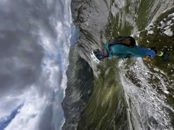
Spectacular ring with departure from Moena, after a strenuous asphalt climb (possibility to avoid asphalt by passing through an internal forest road). Reached Passo San Pellegrino, the real effort begins, first destination is Rifugio Selle. After a short refreshment, continue towards Taramelli refuge (spectacular).
After a few bends, the last strenuous ascent to Rifugio Vallaccia and then to Forcella Vallaccia begins. From here continue downhill along the spectacular 606 trail to the valley.
Medium difficulty: S2/3
Maximum difficulty: S3


Local weather
Today

19 °C
Tonight

12 °C
Tomorrow

17 °C
Tomorrow night

8 °C
Wednesday

20 °C
Wednesday night

11 °C
Graph
Nearest Routes
55,87 km
Km
+1 637 mt
Vertical meters
Route difficulty
Landscapes
2023/07/25
- Italy - Trentino-Alto Adige/Südtirol, TN 64,76 km
Km
+2 100 mt
Vertical meters
Route difficulty
Landscapes
2023/07/27
- Italy - Trentino-Alto Adige/Südtirol, TN 47,84 km
Km
+2 292 mt
Vertical meters
Route difficulty
Landscapes
2023/07/28
- Italy - Trentino-Alto Adige/Südtirol, TN 35,59 km
Km
+1 551 mt
Vertical meters
Route difficulty
Landscapes
2023/02/26
- Italy - Trentino-Alto Adige/Südtirol, TN 24,50 km
Km
+1 500 mt
Vertical meters
Route difficulty
Landscapes
21,06 km
Km
+530 mt
Vertical meters
Route difficulty
Landscapes
41,88 km
Km
+2 190 mt
Vertical meters
Route difficulty
Landscapes
2024/07/12
- Italy - Trentino-Alto Adige/Südtirol, TN 31,65 km
Km
+1 250 mt
Vertical meters
Route difficulty
Landscapes
28,10 km
Km
+791 mt
Vertical meters
Route difficulty
Landscapes
2022/08/19
- Italy - Trentino-Alto Adige/Südtirol, TN 51,42 km
Km
+2 048 mt
Vertical meters
Route difficulty
Landscapes


 Italiano
 Deutsch
