HOME RANKINGS CHALLENGES ROUTES POI PLANNING SEARCH LOGIN
Italy - Trentino-Alto Adige/Südtirol, BZ
2022/09/19 16:02:17

Alpe di Tires

3 Downloads
0
 
Author
Place
Italy - Trentino-Alto Adige/Südtirol, BZ
Km
37,99 km
Elapsed time
06:29:09
Vertical meters
+1 851 mt (991 - 2435)
Route difficulty
Landscapes
Last update
2023/06/25 08:23:41
Comments
0
Description

A technically easy and scenic trail at Alpe di Tires, on the Siusi plateau.

Departure from S. Valentino, on the road between Siusi allo Sciliar and Campaccio, at the arrival of the cable car, where there is also a convenient but expensive parking lot (20?) Since I was in sweet company we preferred to avoid the ascent on bitumen and took the cable car, but as an alternative there was also the use of the car up to Campaccio (road open from 5 pm to 9 am, then only residents pass). In short, the start is in several places, just get to the alp somehow.

You start on comfortable forest roads, which distinguish the entire Alpe, albeit with immediately some nice ramps that are not too long.

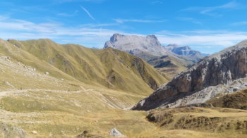
Arrived at the pass at 2100 meters begins the real climb always on forestry, 400 meters of elevation gain with ramps up to 24% that will take your breath away and the view to the enchanting panorama that surrounds you.

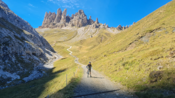
But believe me, the effort (a lot) is worth the view from the hut. You will see few who venture out on traditional bikes, and if you do you will be encouraged by the hikers who are climbing with you. And when you are at the hut, as a reward, a serving of Kaiserschmarrn will restore your strength.

The descent follows the forest roads to Saltria, but you can also widen the loop further at will off the marked trail. From Saltria an uphill asphalt road will take you back to Campaccio and then down to where you started.

So in total there is nothing technical, but 2 stars on the difficulty because only with a big heart do you get up there on your bike.

Download our free mobile app to send this route to your Garmin device or to navigate it on OSM maps. Android - iOS

Graph

Nearest Routes

2023/03/07
- Italy - Trentino-Alto Adige/Südtirol, BZ
nonnocarb
(266)
36,18 km
Km
+1 590 mt
Vertical meters
Route difficulty
Landscapes
2023/02/26
- Italy - Trentino-Alto Adige/Südtirol, BZ
nonnocarb
(266)
36,49 km
Km
+1 550 mt
Vertical meters
Route difficulty
Landscapes
2023/03/04
- Italy - Trentino-Alto Adige/Südtirol, BZ
nonnocarb
(266)
50,79 km
Km
+1 800 mt
Vertical meters
Route difficulty
Landscapes
2022/10/22
- Italy - Trentino-Alto Adige/Südtirol, BZ
nonnocarb
(266)
39,26 km
Km
+1 886 mt
Vertical meters
Route difficulty
Landscapes
2023/02/26
- Italy - Trentino-Alto Adige/Südtirol, BZ
nonnocarb
(266)
38,20 km
Km
+1 601 mt
Vertical meters
Route difficulty
Landscapes
2023/02/26
- Italy - Trentino-Alto Adige/Südtirol, BZ
nonnocarb
(266)
39,56 km
Km
+1 700 mt
Vertical meters
Route difficulty
Landscapes
2023/03/06
- Italy - Trentino-Alto Adige/Südtirol, BZ
nonnocarb
(266)
70,00 km
Km
+2 200 mt
Vertical meters
Route difficulty
Landscapes
2023/03/07
- Italy - Trentino-Alto Adige/Südtirol, BZ
nonnocarb
(266)
52,68 km
Km
+1 700 mt
Vertical meters
Route difficulty
Landscapes
2023/02/25
- Italy - Trentino-Alto Adige/Südtirol, BZ
nonnocarb
(266)
30,60 km
Km
+1 250 mt
Vertical meters
Route difficulty
Landscapes
2023/06/19
- Italy - Trentino-Alto Adige/Südtirol, BZ
28,19 km
Km
+1 800 mt
Vertical meters
Route difficulty
Landscapes

0 Comments