
 Italiano
 Deutsch
2023/05/12 17:41:58
Morbegno - Alpe Piazza
Author

Place
Italy - Lombardia, SO
Km
33,25 km
Elapsed time
00:00:00
Vertical meters
+1 743 mt (0 - 0)
Route difficulty
Landscapes
Last update
2023/06/19 08:41:36
Comments
Description
A classic of the lower Valtellina.
Start from Morbegno and follow the road to the San Marco Pass. At an elevation of about 1300 m you will find the road on the left indicating the Alpe Piazza hut. The descent begins above and behind the refuge. Technical and long, all on trail, it requires good downhill skills to enjoy.
EDIT: I have updated the GPS track to avoid the bad section.
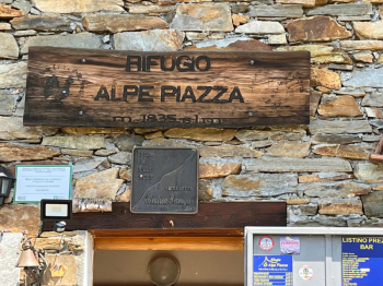
Photo by alf71
Graph
Nearest Routes
34,71 km
Km
+1 288 mt
Vertical meters
Route difficulty
Landscapes
26,96 km
Km
+1 540 mt
Vertical meters
Route difficulty
Landscapes
21,91 km
Km
+1 603 mt
Vertical meters
Route difficulty
Landscapes
11,90 km
Km
+650 mt
Vertical meters
Route difficulty
Landscapes
25,10 km
Km
+1 590 mt
Vertical meters
Route difficulty
Landscapes
29,79 km
Km
+1 500 mt
Vertical meters
Route difficulty
Landscapes
52,37 km
Km
+2 400 mt
Vertical meters
Route difficulty
Landscapes
54,49 km
Km
+2 439 mt
Vertical meters
Route difficulty
Landscapes
36,36 km
Km
+2 403 mt
Vertical meters
Route difficulty
Landscapes
26,51 km
Km
+1 200 mt
Vertical meters
Route difficulty
Landscapes