
 Italiano
 Deutsch
2023/03/07 22:34:46
Spondigna Kopflplatte
Author

Place
Italy - Trentino-Alto Adige/Südtirol, BZ
Km
47,18 km
Elapsed time
07:09:41
Vertical meters
+1 500 mt (766 - 2417)
Route difficulty
Landscapes
Last update
2023/03/09 10:36:01
Comments
Hotels
Description
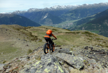
Very challenging and long itinerary, but with exceptional views and very fun trails!
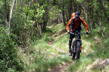
From Spondigna we climb to Tanas and then on forest trail to Tanaser Stierhütte. From here a fairly long push section with some pedaled sections and you reach the top of Kopfplatte - La Lasta, with magnificent views. You descend on the very enjoyable trails 21 and 22 to Spondigna. If you still have strength, you can take an easy pedal ride to Glorenza
Local weather
Thu 00:00

17 °C
Thu 12:00

26 °C
Fri 00:00

20 °C
Fri 12:00

23 °C
Sat 00:00
17 °C
Sat 12:00

25 °C
Graph
Nearest Routes
54,32 km
Km
+2 227 mt
Vertical meters
Route difficulty
Landscapes
37,74 km
Km
+2 018 mt
Vertical meters
Route difficulty
Landscapes
84,83 km
Km
+2 050 mt
Vertical meters
Route difficulty
Landscapes
2023/03/02
- Italy - Trentino-Alto Adige/Südtirol, BZ 40,98 km
Km
+1 980 mt
Vertical meters
Route difficulty
Landscapes
2023/03/04
- Italy - Trentino-Alto Adige/Südtirol, BZ 85,06 km
Km
+2 720 mt
Vertical meters
Route difficulty
Landscapes
2023/03/04
- Italy - Trentino-Alto Adige/Südtirol, BZ 45,04 km
Km
+1 520 mt
Vertical meters
Route difficulty
Landscapes
2023/07/18
- Italy - Trentino-Alto Adige/Südtirol, BZ 48,77 km
Km
+1 461 mt
Vertical meters
Route difficulty
Landscapes
85,80 km
Km
+2 800 mt
Vertical meters
Route difficulty
Landscapes
23,08 km
Km
+1 700 mt
Vertical meters
Route difficulty
Landscapes
2024/09/11
- Italy - Trentino-Alto Adige/Südtirol, BZ 24,82 km
Km
+1 700 mt
Vertical meters
Route difficulty
Landscapes