Italiano
 Deutsch
Colle di Valcournera 3100 m

CycloAlpine route, technical descent, last 50 m to the col tricky.
Colle di Valcournera already mapped here 20 hours and visited several times even when you could still climb direct from the steep final gully, but given the beauty of the descent and place deserves ad hoc itinerary.
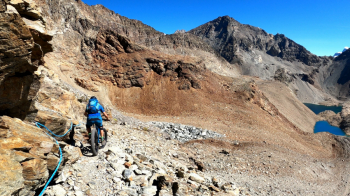
Start from Crepin, Valtournenche 1560 m ample parking. Usual pedal climb to Promoron 1850 m but if you have time go over parallel 8A, very nice and exposed in places with some pushing. From Promoron on drizz directly to Rifugio Barmasse 2165 m. Steep pedal to Chevalley 2310 m. Alternating scenic pedaling, lots of pushing and healthy Portage to the beautiful Perucca Refuge 2900 m (see also this Perucca Refuge. Continue with easy pushing until below the pass where logic says to leave the bike but if you are reading here so healthy you are not so bike on your back and FBL. Several sections equipped with steps and cables are to be done carefully. At the col wonderful view even if not 360 and that freaking M.Rous looking at me and bullying me ...
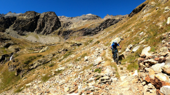
Descent ON: always FBL but also a couple of small pieces in saddle fills diaper easy but very exposed. Past the ropes trail becomes "easy" and scenic in fantastic environment. From the Refuge in addition to the trail there are many lines to choose at will on super grippy rocks and looking good not extreme. 2 steps near the waterfall for me remain off limits but are certified doable. Rest of trail up again to Chevalley still very nice and technical. Ascent to Cignana Window and M.Pancherot 2614 m obligatory. Known and very remarkable panorama. Descent to window 2 FBL to not end up in the lake. Then classic AV, beautiful always and in any case. We retrace the tunnel service road to Liortere and with very nice cuts return to Crepin.
In conclusion: route not unheard of and already proposed in various forms but in this way alternative and of sure interest even for super trialists.
Technical Difficulty: Very Difficult
Physical condition: Hard
www.ciclodisagio.com