
 Italiano
 Deutsch
2022/08/22 09:22:36
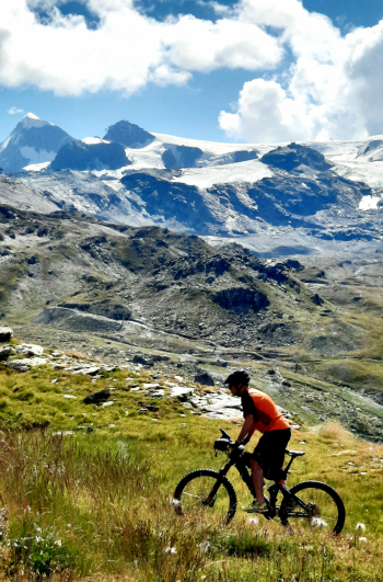
Duke of the Abruzzi Refuge
Author

Place
Italy - Valle d'Aosta, AO
Km
19,23 km
Elapsed time
05:45:50
Vertical meters
+899 mt (1961 - 2803)
Route difficulty
Landscapes
Last update
2022/08/22 09:24:23
Comments
Hotels
Description
Very scenic route starting in Cervinia (camper area) and going up to the Duca degli Abruzzi refuge at 2800 meters, just below the Matterhorn. Rather comfortable ascent on a forest road with only a few rocky sections. You can descend by the same road or by the path that cuts through the hairpin bends, with some very challenging sections that force you off your bike
Local weather
Mer 00:00

14 °C
Mer 12:00

20 °C
Gio 00:00
12 °C
Gio 12:00

20 °C
Ven 00:00
14 °C
Ven 12:00
17 °C

Graph
Nearest Routes
14,52 km
Km
+864 mt
Vertical meters
Route difficulty
Landscapes
47,97 km
Km
+2 400 mt
Vertical meters
Route difficulty
Landscapes
28,05 km
Km
+2 000 mt
Vertical meters
Route difficulty
Landscapes
27,80 km
Km
+2 099 mt
Vertical meters
Route difficulty
Landscapes
47,61 km
Km
+2 400 mt
Vertical meters
Route difficulty
Landscapes
2024/05/08
- Italy - Valle d'Aosta, AO 32,97 km
Km
+1 521 mt
Vertical meters
Route difficulty
Landscapes
33,54 km
Km
+1 450 mt
Vertical meters
Route difficulty
Landscapes
28,72 km
Km
+1 121 mt
Vertical meters
Route difficulty
Landscapes
2023/08/27
- Switzerland 27,22 km
Km
+1 332 mt
Vertical meters
Route difficulty
Landscapes
19,73 km
Km
+1 385 mt
Vertical meters
Route difficulty
Landscapes