
 Italiano
 Deutsch
Le alture genovesi: Alta Via il Gorzente e il Gandalf Trail
Well-tested and well-known itinerary on the Genovese heights bordering the more remote parts of the Alexandria region. I am including it because there are some noteworthy new features and the ride done this way is really nice for lovers of the genre.
To begin with we start from Campomorone where the climb, unlike several routes, proceeds from Pontedecimo which with a few comfortable hairpin bends and a straight uphill all asphalted section leads us to Madonna delle Vigne where a pleasant all pedaled eat and drink path will begin that will capulary us directly to the village of Pietralavezzara. Now classic paved section to get to Passo della Bocchetta where the long stretch on the Alta via dei Monti Liguri begins, initially on paved road and then on the fantastic and scenic trail 5.
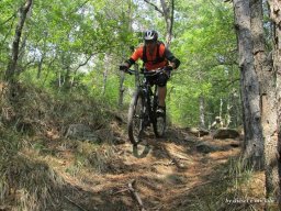
You pass under Mount Leco and under Mount Taccone almost entirely in the saddle with very few pushing sections. Upon reaching Prou Perseghin we continue on the Alta Via to below Bric Guanà where the novelty of the day begins! After a careful online search, the trail we are going to ride on turns out to have never been done with fat wheels but only by hikers on foot, so if not, it may be that we have opened a new possibility to ride! Exactly so, the trail after a very daunting first section, short, all stony, arrrives to a nice scenic traverse to be done all in the saddle until a short push relaunch then again in the saddle in the pine forest and after a second and short push relaunch we are on the Bric Nasciu. And we did well! Remarkably beautiful place overlooking the Gorzente Lakes Valley with Monte Figne, Lago Lungo and Lago Bruno framing it! Spectacular!
After a restorative break savoring a tasty focaccia we get back in the saddle. A very steep technical freeride section awaits us where the trail is not very cyclable. Once we finish the steep and pass the Partisan Shrine, we go through a small gate and get back in the saddle. The technical trail initially then easier crosses a very wild and rewarding creek gorge!
Arriving at the Guardians' House, we take the easy Lakes Road that skirts Lake Lungo on the flat and then on infima cemented road of the hard slopes we arrive at Passo Prato Leone where we will take the fun trail 12, Next bitumen uphill. At Colla di Praglia we turn left to take the long dirt road that will lead us to Monte Pennello with its superb view of the sea and Genoa city. We put on our protective gear and down the fantastic Gandalf Trail. Very hard, technical and physical trail at the end you will be worn out. Ligurian pitruni will crave your bones, but with good mastery and technique you can do it all in the saddle except for a few passes.
Arriving in Camposilvano intoxicated and worn but alive, it's uphill for about 500 meters of elevation gain arriving at the Sanctuary of Mount Figogna where the long descent to Campomorone will begin. Fun guaranteed on the fast Super Flow Pilastrino+Traliccio trails. But it's not over! One more stretch on asphalt first up then down and following uphill along the former guidovia we arrive at the last treat of the day the TORNANTISSIMA trail pulled to a shine, very fun. Return to Campomorone on short paved section.
WARNING: long and physically exhausting ride. Gandalf Trail is very difficult, refrain Sunday overalls and leggings. The trail down to the lakes from the Bric Nasciu has a few sections that are a bit tricky but really worth it. overall very rewarding ride for lovers of the genre.
NB: before setting out make sure of favorable weather and total absence of Maccaja or low clouds.
The focaccia with onions from Campomorone is the SurPlus of the ride!!!


